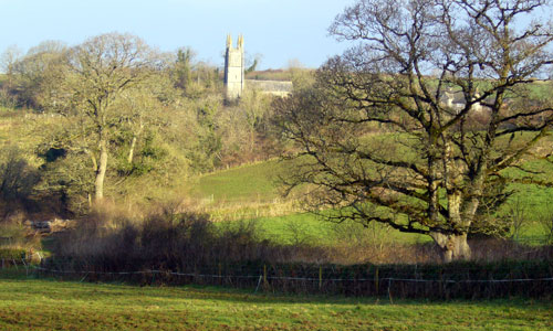
This is an east-west ridge of elevated land, separating the valleys of the Lyd and Tamar. It is an open, quiet landscape, with long views over the woodland and fields of the surrounding valleys. The hill tops retain their moorland feel, and the prehistoric archaeological features add a sense of time-depth to the landscape. Isolated farms nestle in sheltered valleys, and historic villages and hamlets are scattered on the valley sides, their square-towered churches providing landmarks.
-
Context
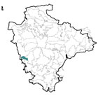
 This relatively small area comprises elevated land overlooking the northern part of the Tamar valley. To the north is a gradual transition to the Upper Tamar Tributary Valleys, and to the east a gradual transition to the Tavistock Dartmoor Fringes. To the south and west the area merges with the lower-lying land of the Middle Tamar Valley and River Tavy Middle Valley.
 -
Constituent Landscape Character Types
Constituent LCTs: 2D: Moorland Edge Slopes, 5A: Inland Elevated Undulating Land, 1F: Farmed Lowland Moorland and Culm Grassland. Part of NCA: 151: South Devon -
Distinctive Characteristics
- Underlying geology of Carboniferous mudstones and sandstones, creating poor quality soils.
- An elevated topography of gently rounded hills forming an east-west ridge.
- Springs rising on high ground and forming small tributary streams, flowing into the Tamar to the south and Lyd to the north.
- Scattered blocks of deciduous woodland and occasional linear shelterbelts.
- Agriculture mainly pastoral, with some areas of arable production, particularly on south-facing slopes.
- Large, regular fields on higher land and smaller, semi-irregular fields on valley sides, divided by hedgerows or hedgebanks.
- Scattered orchards throughout the area.
- Isolated patches of heathland and Culm grassland on high ground.
- Prehistoric enclosures and barrows on hill summits; earthwork remains of Poflett deserted medieval village which are a landscape feature.
- Remnants of historic industrial activity (shafts, quarries, processing areas and transport links) still visible in the landscape e.g. around Chillaton,
- A relatively unsettled area, with isolated farms in sheltered valleys, and occasional nucleated hamlets and villages built of granite and slate.
- Straight roads across areas of former moorland, with more sinuous roads along valley sides.
- Occasional aggregate quarries.
- Telecommunications mast just west of The Beacon that forms a locally-prominent landmark.
- A landscape with an elevated, open feel and views over the valleys to the north and south; also long views east towards Brentor and Dartmoor, and west into Cornwall.
Evaluation
-
Special Qualities and Features:
- High scenic quality – southern part of the area lying within the Tamar Valley AONB.
- Long and highly scenic views over the Lyd and Tamar valleys as well as towards Dartmoor.
- Part of the setting of Dartmoor National Park.
- Lack of settlement and open landscape character, creating a sense of emptiness and isolation.
- Moderately high levels of tranquillity, and dark night skies across the area.
- Several CWSs, including woodland and unimproved grassland sites.
- Prominent prehistoric sites (including Castle Park Camp and The Beacon round barrow cemetery) designated as SMs.
- Areas around Chaddlehanger, Foghanger and Narracott with relatively well-preserved medieval strip fields.
- Conservation Areas covering the historic cores of Milton Abbot and Lamerton.
- Farmhouses, farm buildings and villages in the local vernacular of granite and slate.
- Square-towered, sometimes isolated churches, forming distinctive features in the west.
- A network of quiet lanes and public rights of way providing good recreational access.
Forces for Change and Their Landscape Implications:
-
Past and Current
- Mineral extraction, particularly just outside the area to the west, impinging on westward views.
- Post-war agricultural intensification resulting in loss of field boundaries and other traditional farm habitats such as field margins; loss of medieval field boundaries has been particularly high in the west of the area.
- Agricultural improvement, drainage and enclosure of high land, bringing loss of grassland and moorland, with consequent impacts on insects, butterflies and ground nesting birds.
- Localised poor management of woodland and shelterbelts, affecting their role in the landscape.
- Prominent telecommunications mast on high ground west of The Beacon.
-
Future
- Changes in agricultural grants and funding potentially affecting grazing levels and the repair of traditional landscape features such as hedgebanks.
- Climate change potentially affecting growing seasons, temperature and precipitation levels, resulting in habitat loss and changes in species composition.
- Potential introduction of new crops (e.g. bio-energy crops and crops suited to a changing climate) which do not fit with current landscape patterns.
- Farm diversification and splitting of land into ‘hobby farms’ which change farming patterns and impact on landscape character.
- Longer growing season and increased growth rates of vegetation (e.g. bracken, gorse and secondary woodland) leading to further scrubbing up of hedgebanks and rough grazing land.
- Increased demand for wind turbines and communications masts on higher ground, potentially affecting AONB skylines and setting of Dartmoor National Park.
- Increased demand for domestic and community-scale solar panels and small wind turbines, with cumulative impacts on the landscape and built form of the area.
- Development pressure leading to potential demand for new aggregate quarries both within the area and visible in views from it.
- Further recreational demand from expanding urban centres in the vicinity, such as Tavistock.
- Increase in UK-based tourism with associated demands for new attractions (e.g. golf courses) and infrastructure, as well as an increase in traffic levels, car parking, and farm conversions.
Strategy
-
Overall Strategy:
To protect and enhance the landscape’s scenic quality and views, and its function as a setting for Dartmoor National Park. Sustainable agriculture is encouraged, and the area’s agricultural habitats and heritage features (such as hedgerows, hedgebanks, shelterbelts and orchards) are repaired or replanted and well managed. Upland moorland and grassland habitats are reinstated and managed through sustainable levels of grazing. Archaeological sites and historic buildings such as churches are protected and retained as features in the landscape. Recreation within the landscape is encouraged.
Guidelines:
-
Protect
- Protect and manage existing traditional orchards.
- Protect and manage remaining pockets of moorland and Culm grassland.
- Protect and manage the area’s prehistoric archaeological sites and their settings, improving visitor access and interpretation where appropriate.
- Protect the area’s sparsely settled character and views to high moorland; carefully control new development outside existing settlement envelopes.
- Protect the strong unifying local vernacular of granite and slate; new development should utilise similar materials and styles whilst seeking to incorporate sustainable design.
- Protect the area’s open skylines and views, particularly those on the northern edge of the Tamar Valley AONB and within the setting to Dartmoor National Park.
- Protect the landscape’s network of quiet lanes enclosed by species-rich hedgebanks, resisting unsympathetic highways improvements or signage.
- Protect and repair characteristic built features such as church towers.Protect the area’s tranquillity, and its dark night skies, resisting development which would compromise these qualities.
-
Manage
- Manage (and repair where necessary) traditional field boundaries such as hedgerows and hedgebanks.
- Manage field margins and road verges to maximise their biodiversity, for example through the introduction of wild flower seed, and cutting at appropriate times of year.
- Manage woodland and shelterbelts using traditional techniques (such as coppicing) to increase their age and species diversity.
-
Plan
- Plan for the introduction of new orchards, possibly as community projects linked with local food production; these should fit into the historic landscape character, and should re-use the surviving ridges of former orchards if possible.
- Plan to create, extend and link semi-natural habitats such as heathland, Culm grassland, hedgerows and woodlands; protect and strengthen historic landscape character by targeting woodland planting on areas shown as woodland on historic maps.
- Plan for long-term restoration of upland moorland where appropriate.
- Plan to ensure that any new quarrying activities are visually unobtrusive.