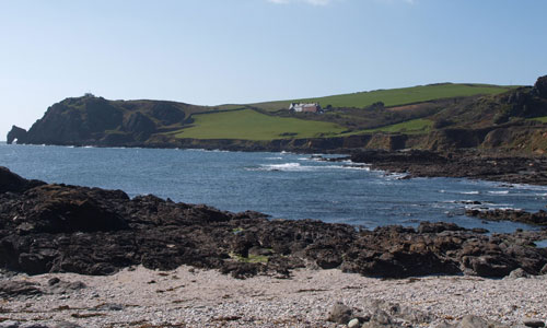
This landscape of elevated coastal plateau rises gently towards the coast affording distinctive views inland across and down the Salcombe to Kingsbridge Estuary and as far as Dartmoor. It drops abruptly into the sea with dramatic cliffs forming a spectacular rugged coastline; and between Prawle Point and Start Point raised beaches (some of which are farmed) are a defining feature revealing the effects of past coastal erosion during time of higher sea levels. Above the cliffs areas of colourful bracken, gorse and blackthorn often occur, providing important habitat for birds including cirl bunting. Although it appears relatively uniform in height, the plateau is incised by coastal combes containing small streams and the upper reaches of tributaries to the Salcombe to Kingsbridge Estuary. Along the coast this landscape has an ‘edge of the world’ feel, offering exhilarating walks and a strong sense of tranquillity and isolation.
-
Context
This area comprises an elevated coastal plateau and rugged coastline running east-west from Bolt Tail to Start Point and flanks the southern reaches of the Salcombe to Kingsbridge Estuary. To the south, east and west the landscape is fringed by the sea and to the north the boundary of this area is marked by a transition to a slightly lower lying inland plateau landscape which is less influenced by the coast.
-
Constituent Landscape Character Types
Constituent LCTs: 1B: Open Coastal Plateau, 3G: River Valley Slopes and Combes, 4D: Coastal Slopes and Combes, 4H: Cliffs Part of NCA: 151: South Devon -
Distinctive Characteristics
- Elevated coastal plateau which rises distinctively towards the coast and is underlain by schists – hard igneous rocks giving rise to distinctive headlands.
- Landscape dissected by small streams in coastal combes and the upper tributary valleys of the Salcombe to Kingsbridge Estuary.
- Sparse woodland cover, although wind-blown sculptured hedgerow trees are a feature.
- Mainly mixed farming with medium to large field sizes on the plateau tops defined by Devon hedgebanks, often constructed using local hard schists.
- Nature conservation interest focuses on the coastal fringe and cliffs and includes extensive areas of coastal grassland, bracken, gorse and blackthorn scrub and areas of mixed farmland with bird interest.
- Extensive, visible prehistoric landscape features on the cliff edges.
- Clustered hamlets and villages at road crossings on the plateau and within the coastal combes; occasionally centred on a square-towered church (e.g. Prawle); farmsteads scattered throughout, nestled in dips.
- Some development associated with recreation and tourism including parking areas and caravan sites.
- Strong local vernacular with common use of slate in roofs as well as wall hangings, with some cob/ render cottages, often thatched.
- High tranquillity and dark night skies away from Salcombe.
Evaluation
-
Special Qualities and Features:
- Unspoilt and very exposed coastal skylines with views out to sea and inland down and across the Salcombe to Kingsbridge Estuary and to Dartmoor.
- High scenic quality reflected in designation as part of the South Devon AONB and Heritage Coast.
- Dramatic coastal scenery including cliffs, headlands, hidden coves, offshore rocks, caves, raised beaches, wave-cut platforms and secluded beaches.
- Sense of isolation, tranquillity and remoteness, enhanced by natural qualities of the coast and exposure to sea and limited car access.
- Coastal habitats including coastal grassland and scrub including part of the Prawle Point and Start Point SSSI, South Devon Shore Dock SAC and Bolt Head to Bolt Tail SSSI, supporting outstanding assemblages of plants, lichens and invertebrates, as well as many CWSs and the fresh water lagoon at Widdicombe Ley.
- Wildlife-friendly mixed farming systems supporting cirl bunting and rich arable weed communities – some of international importance.
- Important co-axial field systems on the cliff edges along with hilltop enclosures, Iron Age hillforts (e.g. Bolt Tail), hut circles and medieval farmsteads; many are SMs.
- Hallsands – remaining few houses of the original village seen clinging to the coast and dramatically illustrating coastal erosion due to former shingle extraction used to build Devonport dockyard.
- Lighthouse at Start Point, a local landmark; and Prawle Point, the most southerly point in Devon.
- Picturesque villages (associated with fishing and tourism) many of which have Conservation Areas with traditional buildings linked by narrow winding lanes.
- Area valued for recreation and tourism and includes South West Coast Path.
- National Trust coastal ownership including Bolt Tail to Bolt Head and significant land between Kingsbridge estuary and Prawle Point.
Forces for Change and Their Landscape Implications:
-
Past and Current
- Hedgerow removal in the drive for agricultural intensification.
- A trend towards larger farm buildings which are not of traditional character, and often visually intrusive in the landscape.
- Changes to the pattern of farm units, such as amalgamation of holdings to increase farm viability and the break-up of farms when farmhouses are purchased separately from their land.
- Past loss of coastal heathland as a result of poor management or enclosure for agricultural use; and under-grazing on cliff tops and steep valley sides, leading to a spread of scrub.
- Re-establishment of coastal grazing and reversion of areas of cliff-top land e.g. East Soar Farm.
- Past agricultural changes, reducing habitat for farmland birds and arable plants – now partly reversed.
- Coastal erosion as a result of shingle extraction and loss of coastal settlement at Hallsands.
- Prominent telecommunications masts at Start Point.
- Small-scale landscape impacts from tourism and recreation, such as litter, unauthorised camping, and traffic on narrow lanes particularly around Start Point.
- Growing demand for facilities such as caravan parks, holiday accommodation, hotel development and visitor attractions – many as farm diversification enterprises.
- Peace and tranquillity interrupted by high volumes of visitors in summer months.
- Increased rates of bracken and gorse growth resulting from warming climate, making management of coastal habitats more challenging.
-
Future
- Uncertainty over future agricultural grants and subsidies, potentially affecting: farm viability and management of landscape features such as hedgerows; habitat management and coastal grassland restoration schemes; and the continuation of mixed farming.
- Changes in seasonal weather patterns and the introduction of new species, pests and diseases resulting from climate change, potentially affecting agriculture and habitats such as woodland.
- Increased demand for communications masts on higher ground as well as for domestic and community-scale solar panels and small wind turbines, with cumulative impacts on landscape.
- Growth in renewable energy sources, including biomass crops and offshore and onshore wind farms, which potentially have a landscape impact.
- Higher sea level and storm frequency as a result of climate change leading to increased coastal erosion.
Strategy
-
Overall Strategy:
To protect the landscape’s undeveloped character, scenic quality, rural character and strong sense of place within the South Devon AONB. The area’s internationally-important coastal habitats are protected and managed to strengthen them against climate change. The spectacular geology of the area is appreciated and enjoyed. The historic fabric of the area is protected and enhanced. Current agricultural land use is sustained, and distinctive landscape features (such as the schist hedgebanks) are retained. Sustainable recreational use of the area is encouraged.
Guidelines:
-
Protect
- Protect and sensitively interpret the coastline’s outstanding geological and geomorphological features and raise awareness of the dynamic nature of the coast e.g. Hallsands.
- Protect historic and archaeological sites, including the clearance and interpretation of the co-axial field systems.
- Protect the qualities of local lanes and hedgebanks, resisting highways improvements and intrusive signage and retaining green lanes and tracks to ensure significant parts of the coast remain inaccessible.
- Protect the open and undeveloped qualities of the coastal plateau avoiding the siting of new development and vertical structures on prominent skylines immediately above or along the coastline, which would be highly visible across this landscape and further inland.
-
Manage
- Manage semi-natural coastal habitats to maximise their biodiversity value and strengthen their resistance to coastal squeeze and/or climate change; restore and develop areas of coastal heath, and create buffer zones between cliff communities and improved agricultural land where possible.
- Manage farmland, and sustain current agricultural use, keeping buildings, hedgerows and hedgebanks in good repair. Where farm diversification does occur, ensure it has minimal impact on the character of the landscape.
- Continue to support mixed farming systems which provide habitat for farmland birds and arable weed communities.
- Manage recreation so that local people and visitors can enjoy the landscape in a sustainable way.
- Manage Devon hedgebanks and in particular the hard schist hedgebanks which are distinctive to this area.
-
Plan
- Plan for sea level rise and coastal erosion as a result of climate change, balancing the need to prevent settlement flooding with allowing natural processes wherever possible; ensure local communities are involved in decision-making.