The colourful patchwork of fields, thick hedgerows and distinctive red soils visible in this area combine to form a quintessential ‘Devon’ scene. The area is the ‘gateway’ into Devon when viewed from the major transport corridors (road and rail) which pass through it. Its sense of history as a transport corridor is apparent in the Grand Western Canal, which flows serenely through the area, crossed by distinctive bridges. Despite the presence of busy transport routes and several large settlements, the valley of the River Culm retains a peaceful atmosphere, with the tree-lined river meandering through a wide floodplain.
-
Context
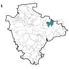
 This area is located to the east of Tiverton, and includes land to the east and west of the M5. To the west is an abrupt descent into the Exe Valley, while to the east the land rises sharply where it meets the Blackdown Hills. To the north is a gradual transition into the Bampton and Beer Downs and to the south (beyond the River Culm) lie the Clyst Lowland Farmlands.
 -
Constituent Landscape Character Types
Constituent LCTs: 3B: Lower Rolling Farmed and Settled Valley Slopes, 3C: Sparsely Settled Farmed Valley Floors, 3E: Lowland Plains, 7: Main Cities and Towns Part of NCA: 148: Devon Redlands -
Distinctive Characteristics
- Varied underlying geology, comprising red Permian sandstones in the western part of the area, Permian mudstones and Triassic sandstones in the central part, and Triassic mudstones in the eastern part, with localised limestone outcrops elsewhere.
- Relatively low and gently undulating landform, separating the wide, flat-bottomed valleys of the rivers Culm, Tone and Lowman.
- Relatively few woodlands, but abundant hedgerows, hedgerow trees and riparian vegetation, giving the landscape a well-treed appearance.
- Predominantly pastoral use on medium-quality soils in the east of the area; more widespread arable cultivation in the western part of the area where soils are more fertile.
- Field boundaries consisting of thick hedgerows with mature hedgerow trees including numerous oaks.
- Fields generally semi-regular in shape, with surviving areas of medieval fields and post-medieval ‘Barton’ fields, particularly west of Halberton, and in the northern and eastern parts of the area.
- Valley-bottom wetlands and occasional blocks of woodland and surviving heathland; hedgerows and verges that also provide wildlife habitats and corridors.
- Numerous surviving orchards, particularly around Holcombe Rogus and Halberton, which are characteristic landscape features and add biodiversity value.
- Archaeological and historic sites from many periods, including prehistoric barrows, Roman forts, and medieval buildings (e.g. village churches and Cannonsleigh Abbey) that lend a sense of time-depth.
- Parkland estates locally influencing landscape character.
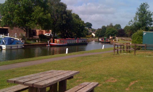
- Grand Western Canal and other historic river features including weirs, bridges and large mill buildings.
- Relatively densely settled with towns and large villages along the rivers (Cullompton, Willand, Uffculme, Sampford Peverell) and near Tiverton; smaller nucleated villages and scattered farms throughout.
- Local vernacular buildings of local stone or white-rendered cob, with slate or thatched roofs.
- Extensive modern development around the peripheries of larger settlements, including industrial development associated with transport routes.
- Extractive industries, including stone quarries and sand and gravel workings.
- An important transport corridor between Devon and Somerset, containing historic and modern routes including the Grand Western Canal, the London-Exeter railway line, the A38 and the M5.
- A network of steep, narrow lanes enclosed between high hedgebanks connecting villages and farms.
- By Devon standards, a ‘busy’ landscape but with some parts retaining a more remote and peaceful feel, particularly in the northern part of the area.
- Unexpected long views e.g. to the Sidmouth Gap from the Swan’s Neck on the Grand Western Canal near Halberton.
-
Special Qualities and Features:
- A very important ‘gateway’ into Devon for people arriving by car on the M5 and A38, and also by train.
- A landscape contributing to the setting of several settlements including Tiverton and Cullompton.
- Several SSSIs, including geological exposures and fossil-bearing rocks; Maiden Down lowland heath, and Tidcombe Lane fen, a wetland site containing over 100 species of flowering plants.
- CWSs including small blocks of ancient woodland and grassland sites.
- Several SMs – including prehistoric barrows, Roman forts, Roman camps and Cannonsleigh Abbey – indicating the importance of this area as a routeway and for settlement for thousands of years.
- Bridwell Park (west of Uffculm) listed grade II on the Register of Historic Parks and Gardens for its late 18th century park and pleasure grounds, including woodland and lake with views across the Culm valley.
- Numerous Conservation Areas (reflecting the dense settlement) including historic cores of Burlescombe, Holcombe Rogus, Halberton, Kentisbeare, Sampford Peverell, Uffculm, Smithincott and Ashill.
- Grand Western Canal from Taunton to Tiverton (opened 1838); associated industrial archaeology, LNR and linear Country Park providing historic, wildlife and recreational interest.
- Grand Western Canal Towpath and National Cycle Route 3 as well as small areas of common land (such as Maiden Down) with public access.
-
Past and Current
- Agricultural intensification, resulting in (for example) field amalgamation, loss of hedgerows, large-scale agricultural buildings, and use of new materials on fields such as fleece and plastic which affect the character of the rural landscape and reduce its biodiversity.
- Reduction in diversity of plant species in hedgebanks and hedgerows (e.g. primroses) as a result of increased traffic (including large farm machinery) and damage to hedgebanks.
- Diversification of farms, often to cater for recreational demand (e.g. fisheries, campsites, equine businesses) introducing new elements into the landscape.
- Development pressure, resulting in development along transport routes; and peripheral growth of settlements within and adjacent to the area which does not reflect traditional styles or layout (e.g. Tiverton, Cullompton).
- Light pollution from towns and roads.
- Construction of transport routes and associated bridges, junctions etc, resulting in visual impacts, loss of tranquillity, loss of wildlife habitats and severing of ecological corridors.
- Extractive industries such as stone quarries and sand and gravel workings, with visual and audible impacts on the landscape.
- Construction of pylons, introducing large-scale vertical elements into the landscape.
-
Future
- Possible future changes in agricultural funding and grants, with effects on livestock numbers, crop types and upkeep of landscape features such as hedgerows, hedgebanks and traditional farm buildings.
- Continued loss of hedgerows and hedgerow trees, potentially resulting in loss of one of the area’s key distinctive features.
- Demand for renewable energy schemes, including wind turbines, solar arrays and biomass crops, potentially introducing large-scale structures into the landscape; domestic and community scale schemes may also have a cumulative effect on landscape character.
- Continued development pressure on edges of larger towns and villages and associated with transport routes, increasing urban influences in the landscape.
- Loss of historic industrial buildings such as mills along the River Culm.
- Climate change leading to increased winter flooding, summer drought and changes in seasonal growth patterns, potentially affecting semi-natural habitats and choice of crops.
- Loss of woodland and trees as a result of new pests and diseases (e.g. Phytophthora), and increased magnitude and frequency of storm events as a result of climate change.
- Threat of invasive water-borne weeds such as Knotweed and Himalayan Balsam, resulting in loss of native riparian vegetation.
-
Overall Strategy:
To protect the area’s characteristic Devon agricultural landscape, and enhance its role as a gateway into Devon. Agricultural land use is encouraged, and associated features such as hedgerows are well-maintained. The biodiversity of agricultural land is increased. Development in the form of settlements and transport corridors is sensitively accommodated. Links between settlements and the countryside are encouraged, and the recreational, historic and wildlife values of the river valleys are enhanced.
-
Protect
- Protect and enhance the characteristic ‘patchwork’ landscape, particularly where it forms a ‘gateway’ into Devon from the M5, A38 and railway line.
- Protect and manage hedgerows, hedgebanks and hedgerow trees, replacing lost sections or trees where possible, to ensure their continuation within the landscape.
- Protect surviving historic buildings, including those in village cores; ensure that any new development outside the largest settlements respects traditional local built forms and styles.
- Protect and manage surviving orchards.
- Protect the Grand Western Canal and its associated features, encouraging its use for education, recreation and as a wildlife habitat.
- Protect surviving historic features such as farm buildings and bridges.
- Protect distinctive narrow lanes and hedgebanks, resisting unsympathetic highways measures and signage, but encouraging a diversity of flowers.
- Protect the sense of peacefulness and remoteness where it survives, particularly in the north and south of the area.
- Protect floodplains, resisting any inappropriate development.
-
Manage
- Manage the agricultural landscape, retaining traditional landscape features and buildings, and enhancing its biodiversity through (for example) grass buffer strips around arable fields.
- Manage trees and woodland, replacing over-mature trees where necessary and educating the public about measures to reduce the spread of infectious tree diseases.
- Manage remaining areas of semi-natural habitat (e.g. wetland, fen and heath) through (for example) appropriate levels of grazing, and achieving an appropriate balance between public access and conservation interests.
- Manage archaeological sites through (for example) suitable levels of clearance and grazing, enhancing their settings and providing access and sensitive interpretation where appropriate.
- Manage parkland, including the replacement of over-mature trees to ensure their continued presence in the landscape and encourage the establishment of open-grown trees within the wider countryside.
- Manage recreational facilities such as Country Parks and Nature Reserves, encouraging links between towns and the countryside.
- Manage and control or eradicate where possible invasive water-borne weeds.
-
Plan
- Plan to link surviving pockets of semi-natural habitats to increase their biodiversity value and resilience to climate change.
- Plan to increase green infrastructure links between larger settlements and the countryside, through (for example) provision of crossings over main roads and railway lines, and opening-up access into the River Culm valley, possibly using the disused railway line.
- Plan screening for insensitive development e.g. housing and industrial estates and large farm buildings.
- Plan well sited and designed future development that incorporates a green infrastructure framework.
- Plan to restore mineral extraction sites to minimise their visual intrusion and maximise their biodiversity value.
- Plan reduced levels of light pollution from settlements and roads.