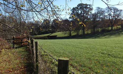
A landscape characterised by its deep valleys and extensive and varied woodland, interspersed with more open, pastoral landscape. The valley of the Iron Mill Stream (a tributary of the Exe) is spectacularly deep and wooded, almost gorge-like in places. The combination of steep slopes, thick woodland, and the sights and sounds of the Iron Mill Stream create an atmosphere which is quiet, secretive, remote and isolated. The enclosed, wooded valleys contrast with the high, airy and spacious pasture above. This higher land is patterned with hedges and punctuated by copses and larger woods, with long-range views in all directions, Exmoor especially catching the eye in views from the northern part of the area.
-
Context
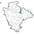
 This area is located to the west of the Exe Valley and is dominated by a series of wooded valleys, including several tributaries of the River Exe. To the east is a gradual transition into the Exe Valley. To the south is another gradual transition into the less wooded landscapes of the Crediton Rolling Farmland and the Yeo, Culm and Exe Lowlands. To the west and north is the higher and more open landscape of Witheridge and Rackenford Moor.
 -
Constituent Landscape Character Types
Constituent LCTs: 1F: Farmed Lowland Moorland and Culm Grassland, 3A: Upper Farmed and Wooded valley slopes, 3C: Sparsely Settled Farmed Valley Floors, 3H: Secluded Valley. Part of NCA: 149: The Culm -
Distinctive Characteristics
- Mainly underlain by Carboniferous Culm Measures geology, with a band of Permian red sandstone running east-west across the central part of the area.
- Undulating, relatively high land containing a series of deep, narrow valleys, some almost gorge-like.
- Numerous narrow, fast-flowing streams forming tributaries of the Exe (including the Iron Mill Stream and the upper reaches of the Dart) in the northern part of the area, or flowing into the River Creedy in the southern part of the area.
- Extensive woodland, including dense deciduous and coniferous valley-side woodlands, plus numerous plantations, copses and hedgerow trees, together creating a characteristically well-wooded landscape.
- Generally medium-quality soils semi-improved pasture, with some pockets of arable land use.
- Thick hedgerows, some high, others closely flailed, enclosing small-medium, mainly semi-regular fields.
- Extensive areas of surviving medieval enclosures and ‘Barton’ fields (dating from the 15th to 17th centuries) in the central and south-eastern parts of the area.
- Valley floor wetlands and occasional pockets of unimproved grassland.
- Farm orchards, hedgerows and hedgebanks also providing important wildlife habitats.
- Prehistoric archaeology (including barrows and Iron-Age hillforts) in prominent positions in the landscape.
- Parkland (e.g. around Cruwys Morchard House and Calverleigh Court) locally influencing character.
- Scattered farms throughout the area (often set back from roads down long tracks) and occasional nucleated historic villages clustered around square-towered churches.
- Variety of domestic and agricultural building materials and styles (cob, red sandstone, thatch and slate).
- Villages linked by steep, narrow lanes often following ridge-tops (suggesting considerable antiquity); high hedgebanks on either side creating a tunnel-like effect, particularly where they drop down into valleys.
- Main roads (A361 North Devon Link Road and the A3072) crossing the area roughly east-west.
- Prominent communications mast at Stoodleigh Beacon.
-
Special qualities and features:
- A landscape of high scenic quality, with enclosed, small-scale, secretive – and sometimes dramatic – valleys contrasting with open, airy hilltops with long views.
- Views to and from Exmoor, contributing to the setting of the National Park.
- High levels of tranquillity (locally reduced by the presence of the A361) and exceptionally dark night skies.
- A strong sense of remoteness and isolation experienced in the tributary valleys, with the atmosphere enhanced by mist in the valley bottoms.
- Extensive areas of ancient woodland particularly in the Iron Mill Stream valley, and around Templeton; this is reflected in the Celtic name ‘Morchard’, meaning ‘great forest or wood’.
- Numerous CWSs, mostly covering woodlands.
- National-Trust owned land south of Withleigh, including woodland with public access.
- Several SMs, including Bronze Age barrows; Iron Age hillforts at defensive sites at Calverleigh Court (overlooking the confluence of the Exe and the Dart) and Cadbury Castle, and a medieval standing cross in Cadbury churchyard.
- Conservation Areas covering the historic cores of Oakford, Stoodleigh, Cadeleigh and Puddington, plus numerous historic buildings including farms, bridges and churches throughout the area.
- A reasonable network of lanes, tracks and public rights of way offering access into the countryside, but with limited opportunities to access woodlands.
-
Past and Current
- Past loss of woodland and planting of coniferous plantations on valley sides (sometimes replacing deciduous woodlands), reducing the extent of the area’s characteristic deciduous woodland and introducing blocks of dark colour into the landscape.
- New pests and diseases affecting tree species (e.g. Phytophthora pathogens) potentially destroying woodlands and hedgerow trees.
- Intensification of agriculture, resulting in (for example) field amalgamation and associated hedgerow loss, increased use of soil fertilizers, and a reduction in the biodiversity of agricultural land.
- Localised farm diversification (poultry sheds, equine businesses etc.) bringing new landscape elements.
- Damage to hedgebanks from machinery and vehicles (including farm vehicles); loss of wildflower species in hedgebanks.
- Invasive water-borne weeds (e.g. knotweed and Himalayan balsam) affecting native riparian vegetation.
- Locally poor footpath maintenance, potentially affecting people’s enjoyment of the countryside.
- Stoodleigh Beacon telecommunications mast, introducing a large, visually-prominent built structure into a landscape with few large-scale or built features.
- The A361 North Devon Link Road, impacting visually and audibly on the local landscape, and reducing the tranquillity of the surrounding area.
-
Future
- Potential changes in agri-environment funding affecting stocking levels, crop choice and maintenance of traditional landscape features such as hedgerows and historic farm buildings.
- Demand for renewable energy schemes, including wind turbines, solar arrays and biomass crops, potentially introducing large-scale structures into the landscape; domestic and community scale schemes may also have a cumulative effect on landscape character.
- Alterations in seasonal weather patterns (e.g. increased summer droughts and winter rainfall) leading to loss of drought- and water-intolerant species and changes in suitability of agricultural crops.
- Increased magnitude and frequency of storm events as a result of climate change, potentially resulting in a loss of woodland and trees.
-
Overall Strategy:
To protect the landscape’s scenic quality, wooded character and strong sense of place. The landscape’s role within the setting of Exmoor National Park is maintained and enhanced. Its woodlands, copses, hedgerows, orchards, parklands and riparian trees are well managed, with good age- and species-diversity, and rich ground flora. The tranquillity found within many of the wooded valleys is retained, and the area’s dark night skies are protected. The agricultural landscape is well-managed and its biodiversity is enhanced. Historic features and buildings within the landscape are protected and kept in good repair.
-
Protect
- Protect woodland and hedgerows, to retain the distinctive well-treed character of the landscape.
- Protect and manage remaining orchards.
- Protect historic lanes and tracks and their associated hedgebanks, resisting unsympathetic signage or highways measures.
- Protect dark night skies and high levels of tranquillity, resisting development which would compromise these qualities.
- Protect the historic character of villages, ensuring that any new development is sympathetic in terms of scale, materials, styles and form.
- Protect historic features within the landscape such as bridges and mills.
-
Manage
- Manage woodlands and copses (including through traditional techniques such as coppicing and grazing) to maximise age- and species-diversity and encourage a rich ground flora; educate the public about the risks of spreading infectious tree diseases.
- Manage hedgerows and hedgebanks, replacing hedgerow trees where necessary; encourage the learning of traditional agricultural skills such as building and repairing hedgebanks.
- Manage plantations to increase their wildlife value and for sustainable timber production.
- Manage farmland, enhancing its biodiversity where possible, for example through the creation of grass buffer strips around arable fields.
- Manage valley floors to maximise their biodiversity and effectiveness as wildlife corridors.
- Manage, and ideally control or eradicate any invasive water-borne weeds.
- Manage archaeological sites with appropriate levels of grazing and clearance, and enable public access and sensitive interpretation where possible; avoid damage ploughing or vegetation growth.
- Manage public rights of way, ensuring paths remain passable and that signage is adequate.
- Manage parkland, including the replacement of mature parkland trees, and establishing open grown trees within the wider landscape to ensure their continued presence within the landscape.
-
Plan
- Plan reversion of plantations to broadleaved woodland on maturity and felling.
- Plan to extend and link semi-natural habitats such as woodlands, wetlands and semi-improved grasslands to increase their value as wildlife corridors, and increase their resilience to climate change; encourage hedgerow planting to link woodlands and copses.
- Plan to explore opportunities to improve public access to woodlands and plantations, including provision for activities such as mountain biking in the least sensitive locations.
- Plan to research effective treatments and preventative measures for Phytophthora pathogens (sudden oak death).
- Plan screen-planting along the A361 in areas where this may be beneficial.