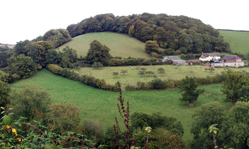
A ‘typical’ Devon landscape characterised by a harmonious patchwork of fields, thick hedges, red soil, deep lanes and attractive villages. This productive, settled agricultural landscape contrasts with the looming mass of Dartmoor, which forms the southern horizon in many views, particularly from the south of the area. Views are often restricted by hedgebanks, but where they occur they are often panoramic. The landscape is diverse, with irregular, often rounded hills dissected by small but well-marked valleys, lending a small scale and intimate appearance to the landscape. The long east-west ridge of the Raddon Hills forms a distinctive landmark, particularly in views from the southern part of the Exe valley.
-
Context
This area comprises the rolling agricultural land to the north west of Crediton. To the north and north-east respectively are gradual transitions to the Witheridge and Rackenford Moors and the Cruwys Morchard Wooded and Farmed Valleys. To the south is a gradual transition to the lower land of the Yeo, Culm and Exe Lowlands. The High Taw Farmland lies beyond the River Yeo to the west.
-
Constituent Landscape Character Types
Constituent LCTs: 1E: Wooded Ridges and Hilltops. 3B: Lower Rolling Farmed and Valley Slopes, 3C: Sparsely Settled Farmed Valley Floors, 3H: Secluded Valleys, 7: Main Cities and Towns. Part of NCA: 148: Devon Redlands, 149: The Culm -
Distinctive Characteristics
- Underlying Carboniferous Culm Measures of sandstone, mudstone and shale, with occasional extrusions of basaltic lava.
- Gently rolling and strongly undulating landform, irregular in form, but with a unifying convex profile to the hills.
- Particularly distinctive and visually prominent east-west ridge of the Raddon Hills.
- Upper reaches of the River Creedy, fed by spring-fed streams.
- Small blocks of woodland and plantation; well-treed appearance enhanced by hedgerow trees, copses, and snaking lines riparian tree cover.
- Fertile soils giving medium-high grade agricultural land, supporting both pastoral and arable agriculture.
- Small to medium sized irregular and semi-regular fields, creating a strong ‘patchwork’ pattern.
- Medieval enclosures surviving around Stokeleigh English, Sandford and Down St Mary; areas of surviving post-medieval ‘Barton’ fields around Cheriton Fitzpaine.
- Fields divided by wide hedgerows or hedgebanks, some tightly-clipped whilst others grown out.
- Semi-natural habitats including wet and valley-side woodland, and valley-bottom wetland sites.
- Surviving orchards (particularly around Sandford and Copplestone).
- Localised parkland influence on the character of the landscape, e.g. from Creedy Park north of Crediton.
- Scattered farms and historic villages and hamlets, often situated at crossroads on valley sides; attractive vernacular domestic and agricultural buildings of cob, render, thatch, slate and local red sandstone.
- Villages linked by narrow hedge-banked roads, often steep and twisting; also modern transport routes through the area, including the Exeter-Barnstaple railway, the A377 and the A3072.
- Away from main roads, a quiet and peaceful landscape, with frequent long views.
-
Special Qualities and Features:
- Occasional dramatic long views across the area or to higher land including Dartmoor, particularly from the Raddon Hills which also provide an important horizon and part of the wider setting of the National Park.
- High levels of tranquillity and dark night skies, particularly in the northern part of the area away from the influence of Crediton and major roads.
- Nymet Barton Marsh SSSI – an extensive area of wetland with rare stands of tussock sedge.
- Pockets of surviving semi-natural ancient woodland, often on valley sides; and larger stands of replanted ancient woodland.
- Several CWSs, including Stockleigh Wood and Stone Ash Wood.
- A long-settled landscape containing features from several millennia, many of which are prominently sited and are SMs, together with and historic farms, manor houses, churches, bridges, tracks, lanes and field patterns.
- Particular archaeological interest associated with prehistoric field system at Stockleigh Pomeroy, Neolithic causewayed enclosure and Iron Age hillfort at Raddon Hill, Bronze Age barrows and medieval churchyard crosses at Down St Mary and Copplestone.
- Many attractive historic villages and Conservation Areas covering the cores of Cheriton Fitzpaine, Stockleigh English, Kennerleigh, Morchard Bishop, Stockleigh Pomeroy, Sandford, Down St. Mary and Bow.
- The Two Moors Way recreational route (linking Dartmoor and Exmoor) running north-south through the western part of the area.
-
Past and Current
- Past agricultural intensification resulting in field amalgamation, increased areas under arable production, use of fertilizers, construction of large farm buildings, reduction in numbers of farmland birds etc.
- Current farming practices with impacts on the landscape including the use of artificial materials (e.g. plastic, fleece) to protect crops.
- Loss of hedgerows, hedgerow trees and hedgebanks, reducing the characteristic ‘patchwork’ effect of the landscape; loss of wild flowers in hedgebanks, possibly due to increased traffic and wide farm vehicles.
- Increased pests and diseases (e.g. Phytophthora) affecting trees and woodlands and threatening the survival of key landscape elements.
- Invasive water-borne weeds (e.g. knotweed, Himalayan balsam) affecting native riparian vegetation and wildlife habitats.
- Loss of tranquillity as a result of traffic on main roads such as the A377.
- Light pollution from Crediton and the A377.
- Recent expansion of Crediton up valley sides, causing the
-
Future
- Changes in levels of agricultural funding and grants, potentially affecting stocking numbers and crop choice and maintenance of landscape features such as hedgerows and historic farm buildings.
- Demand for renewable energy schemes, including wind turbines (particularly on exposed ridgelines), solar arrays and biofuel crops; expansion of domestic and community scale renewables with potential cumulative effect on the landscape and built fabric of the area.
- Development pressure resulting in loss of village character; and continued expansion of Crediton onto higher land, increasing its visibility from the wider landscape.
- Changes to seasonal weather patterns and growing conditions (e.g. summer droughts; winter flooding) causing loss of drought- and water-intolerant species and a changes in cropping patterns.
- Increased frequency and intensity of storm events (as a result of climate change) causing increased flooding and loss of trees and woodland.
-
Overall Strategy:
To protect the landscape’s traditional rural character and undeveloped ridgelines, and to maintain and enhance its role within the setting of Dartmoor National Park. The area’s ‘patchwork’ agricultural landscape is retained and its biodiversity enhanced. Trees, woodlands, hedgerows and hedgebanks are well managed. The area’s remarkably rich built heritage, including numerous historic villages, farms and houses is protected and kept in use.
-
Protect
- Protect important views, undeveloped ridgelines such as the Raddon Hills and the setting of Dartmoor National Park).
- Protect floodplains from development in order to minimise the risk of flooding.
- Protect the highest quality agricultural land from development.
- Protect hedgerows and hedgerow trees to retain the landscape’s ‘patchwork’ character.
- Protect and manage surviving orchards.
- Protect and repair historic buildings and structures, retaining them in use where possible; ensure that any new development is sympathetic in terms of scale, form, style and materials.
- Protect historic lanes and tracks, managing hedgebanks to encourage wild flowers, and resisting unsympathetic highways measures and signage.
- Protect the area’s dark skies and high levels of tranquillity, resisting developments which would compromise these qualities.
-
Manage
- Manage agricultural land, increasing its biodiversity where possible (e.g. through grass buffer strips around arable fields).
- Manage hedgerows and hedgebanks, and encourage hedgerow tree planting; encourage learning of traditional agricultural skills such as hedgerow management.
- Manage woodland and copses (including use of traditional techniques such as coppicing and grazing) to maximise age- and species-diversity, including ground flora; educate the public about how to avoid the spread of infectious tree diseases.
- Manage parkland, including the replacement of mature parkland trees to ensure their continued presence within the landscape and encourage open-grown trees within the wider countryside.
- Manage archaeological sites, introducing sensitive interpretation where appropriate.
- Manage river corridors to enhance their biodiversity and minimise the risk of downstream flooding
-
Plan
- Plan to revert areas of plantation to broadleaved woodland at maturity and felling.
- Plan to extend and link woodlands (possibly through the planting of new hedgerows) and wetlands, to enhance their effectiveness as wildlife corridors and increased their resilience to climate change.
- Plan to improve access into river valleys and woodlands.
- Plan to reduce light pollution from main roads.
- Plan to investigate opportunities for small-scale hydropower schemes.