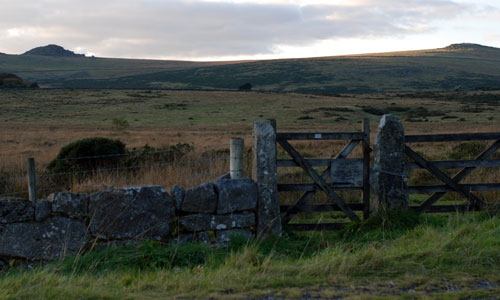
This extensive area of remote and wild land contains the highest land in Dartmoor, rising to 621m at High Willhays. Large expanses of blanket bog, heather and grass moorland form broad, uninterrupted skylines broken only by the occasional tor or rock outcrop. The landscape is crossed by a network of streams and valley mires, with thick deposits of peat and blanket bogs which form the sources of many of the major rivers of Devon including the Dart, Teign and Taw. The high levels of tranquillity and remoteness are occasionally interrupted by sounds relating to the long-standing military use of the moor. The strong time-depth of the landscape is reflected in a rich archaeological resource of human activity over many millennia. The high, open moorland affords expansive and panoramic views across the surrounding lower landscapes within the National Park and as far beyond as Exmoor.
-
Context
 This area comprises the unsettled northern parts of High Dartmoor, north of the Dart valley and south of Okehampton. It contains some of the most remote and elevated landscapes within Dartmoor National Park. To the south and east is a gradual transition to Central Dartmoor, and to the west to the Tavistock Dartmoor Fringes. To the north is a more abrupt boundary with the Moretonhamptead Moorland Fringes and the Upper Tamar Tributary Valleys, marked by the change from open moorland to enclosed fields.
 -
Constituent Landscape Character Types
Constituent LCTs: 1K: Unsettled High Upland Moorland; 1L Upland Moorland with Tors Part of NCA: 150: Dartmoor -
Distinctive Characteristics
- The highest point of the ‘dome’ created by the granite geology which underlies Dartmoor.
- A large-scale upland plateau landform, containing several broad ridges and the highest land in the National Park at High Willhays.
- Occasional tors and rock outcrops dotted along the plateau edges; their distinctive silhouettes contrasting with the surrounding smooth, uninterrupted skylines.
- A major water catchment, with a radiating network of small moorland streams and mires feeding larger rivers.
- An absence of trees, with large expanses of blanket bog (interspersed with patches of grass and heather moorland) grazed by free-roaming sheep, cattle and Dartmoor ponies.
- Archaeological features including ceremonial sites, burial cairns, prehistoric settlements and field systems (particularly associated with the Bronze Age period) giving a strong sense of time-depth.
- Visible heritage from medieval and post-medieval mining activities including tinners’ mills, and ‘streaming’ sites where alluvial tin was extracted from streams and river beds.
- An absence of settlement, roads and footpaths, giving the area an empty, remote and unsettled character.
- Modern and historic military buildings and structures forming distinctive features of this area.
- Extensive panoramic views, particularly to the north over the ridges of central Devon as far as Exmoor, visible on the horizon on clear days.
-
Special qualities and features:
- An open and extensive landscape of exceptionally high scenic quality, within Dartmoor National Park.
- Highest land within the National Park, offering majestic outward views and providing a widely visible backdrop to views from both within and outside Dartmoor National Park.
- Highly distinctive, undeveloped, smooth skylines contrasting with occasional rocky tors.
- Very strong sense of isolation and exposure within this wild, bleak and remote landscape.
- One of the most extensive areas of high tranquillity in Devon.
- Exceptionally dark, starlit night skies beyond the influence of Okehampton.
- Blanket bog and valley mires with thick layers of peat covering a large proportion of the plateau top. These extensive upland habitats are rare in the south-west of Britain and are usually associated with more northern areas. They are of national and international importance (designated SSSI and SAC) and support several rare bird species including ring ouzel, snipe, dunlin, curlew and red grouse.
Blanket bog playing important roles in water catchment/ storage/ filtration and carbon sequestration. - Many CWSs, particularly towards the periphery of the area.
Geological exposures at Sourton and on the Okement, both designated as RIGS. - Numerous SMs reflecting the outstanding archaeological importance of this landscape.
- Black-a-Tor Copse NNR, designated for its high-altitude ancient oak woodland.
Cranmere Pool, site of the first of the famous Dartmoor ‘Letterboxes’, established in 1854. - High recreational value of open access land for those wishing to ‘get away from it all’ (access restricted during military operations).
-
Pats and current
- Military use of large parts of this area since the 19th century, with associated impacts including off-road vehicular use, the building of structures (e.g. warning signs, look-out shelters and flagpoles) and noise related to live firing and helicopters flying overhead.
- Public access restricted by live firing at certain times of the year.
- Historic peat cutting and drainage operations (dating as far back as the medieval period), reducing the area of blanket bog, valley mire and damaging archaeological features.
- Lower numbers of stock on the moor, resulting from declining market values for livestock, changes in agricultural grant schemes and an ongoing decline in traditional upland farming and commoning.
- Recreational use (including concentrated events such as the Ten Tors challenge) resulting in erosion of surface peat and damage to geological features and archaeological sites.
- Traffic noise from the A30 corridor affecting tranquillity levels on the northern fringes of the LCT.
- Localised visual and noise impacts of Meldon quarry on the north-west fringe of the area
-
Future
- Continued military use of the area, with changing military requirements potentially resulting in landscape impacts from new structures, access roads and signage.
- Uncertainty over future agricultural funding levels, with possibility of reduced levels of grazing, causing ‘scrubbing up’ of moorland areas which are currently open.
- Potential drying out of wet heath, blanket bog and valley mires due to more frequent drought conditions in the summer months as a result of climate change. These conditions may also lead to more frequent and intensive moorland fires and erosion, causing damage to archaeological sites.
- Potential increased autumn and winter precipitation levels, requiring management of upland streams, mires and blanket bog to minimise the risk of downstream flooding.
- Longer growing season and enhanced growth rates of vegetation including bracken, gorse and secondary woodland resulting in a decrease in the area of open heather moorland and a ‘scrubbing up’ of upland stream valleys.
- Spread of non-native and alien species in response to a changing climate may affect vegetation patterns and landscape character.
- Potential demands for new water supply and the creation of new reservoirs.
- Drive for increased woodland planting and regeneration – including at the heads of stream valleys on the open plateau – to enhance flood storage capacity, water filtration and carbon sequestration functions, and to strengthen the landscape’s resilience to climate change.
- Continues recreational use (including concentrated events) resulting in erosion of peat deposits, geological sites and archaeological features.
- Vulnerability to increased demand for wind turbines within the open, exposed landscapes of the moorland, as well as in areas outside the National Park visible in long views.
- Pests and diseases affecting natural vegetation communities (e.g. Phytophthora killing bilberry).
-
Overall strategy:
To protect the open and remote character of this landscape within Dartmoor National Park, strengthening its special qualities and conserving its distinctive open skylines. Its rich archaeological heritage – reflecting thousands of years of human interaction – is protected. Internationally important habitats are managed and enhanced through traditional upland farming practices, whilst ensuring the landscape’s resilience to climate change is strengthened to benefit the wider National Park and its surrounding communities. The visual and physical impacts of the area’s military use are minimised.
-
Protect
- Protect the undeveloped character of the open plateau and its qualities of exceptional tranquillity, remoteness and dark night skies.
- Protect the open moorland landscape, avoiding the development of vertical structures and the planting of trees.
- Protect the geological and geomorphological features of the landscape such as tors.
- Protect (through appropriate management) the rich archaeological heritage of the area, in particular the prehistoric and medieval features, and the tinworking remains. The settings of such features should be maintained and enhanced through the use of light grazing and scrub removal where necessary.
- Protect the military heritage of the area.
- Protect the expansive views to and from the National Park which are integral to its setting.
- Protect valuable moorland habitats.
-
Manage
- Manage and enhance tracts of blanket bog, moorland and Rhôs pasture.
- Manage land through the encouragement of a viable farming community, farming the land in a traditional way, using a viable grazing regime which maintains an open moorland landscape and enhances biodiversity.
- Manage livestock to encourage increased numbers of Dartmoor ponies and other local livestock breeds, whilst ensuring numbers remain sustainable and in line with conservation objectives.
- Manage and enhance important wetland habitats, particularly blanket bogs and valley mires, through the management of water flows and control of invasive vegetation to enhance their roles in carbon sequestration and flood storage capacity.
- Manage the natural regeneration of semi-natural woodland and scrub along the upper courses of streams (not on open moorland) to enhance regulation of water flows.
-
Plan
- Plan for the reduction of visual and physical impacts of military activity whilst respecting this long-standing land use (as long as national interests demand its continuation).
- Plan to reduce the visual impact of quarrying activities on the fringe of the area.
- Plan for the creation, extension and linkage of upland habitats, particularly blanket bog, valley mire, heath and heather moorland. Reduce the overall area of acid grassland through encouragement of heather regeneration, whilst retaining areas of importance for species diversity and as a habitat for ground nesting birds.
- Plan to reduce light pollution from Okehampton.
- Plan to reduce noise pollution from the A30, introducing whisper tarmac on the road surface.