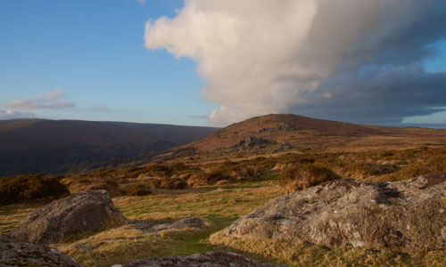
This is a large-scale moorland landscape, sweeping below the high plateaux and summits of the unsettled high moorland. Smooth outlines are punctuated by many tors and jagged rock outcrops, with slopes often strewn with granite boulders and ‘clitter’ (scree). Areas of open moorland grazed by free-roaming livestock are fringed by a strong pattern of newtakes marked by granite walls containing rough grazing land. The landscape contains numerous sites and features of archaeological significance, scattered within a mosaic of heather and grass moorland punctuated by wetland habitats of international importance. Small villages and hamlets occupy sheltered locations, often associated with streams and rivers draining from the moor.
-
Context
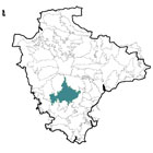
 This area comprises the central part of Dartmoor around Two Bridges. To the north and south are gradual transitions to High Dartmoor, whilst in other directions there are more abrupt boundaries (marked by the change from open moorland to enclosed fields) with the Moretonhampstead Moorland Fringes and the East Dartmoor Moorland Fringes (to the east), the Southern Dartmoor and Fringes (to the south-east and south-west) and the Tavistock Dartmoor Fringes and the River Tavy River Valley (to the west).
 -
Constituent Landscape Character Types
Constituent LCTs: 1L: Upland Moorland with Tors; 2D: Moorland Edge Slopes; 3D: Upland River Valleys; Part of NCA: 150: Dartmoor -
Distinctive Characteristics
- A gently rolling, large scale moorland landscape, with tors punctuating the smooth moorland slopes and skylines, fringed by scatterings of granite boulders and clitter slopes.
- Valley mires and blanket bogs threading through the rolling landscape before feeding into fast-flowing tributary streams, which grow in size and occupy steep sided valleys off the moor.
- Patches of deciduous woodland dominated by oak, ash and beech on valley sides and around settlements.
- Large conifer plantations creating dark blocks with hard edges, contrasting with the smooth, muted landscape backdrop.
- Free-roaming sheep, cattle and ponies contributing to the area’s sense of place.
- Strong pattern of late 18th and 19th century ‘newtakes’ surrounding the moorland core, defined by a regular pattern of granite drystone walls and low hedgebanks, enclosing rough grazing land and occasional species-rich haymeadows; individual and linear groups of trees grow on hedgebanks.
- Heathland cover on more elevated areas, comprising a low-growing patchwork of heather and grass moor, western heath, gorse scrub, tufts of Molinia grass, bracken, and occasional windswept trees.
- Numerous sites and features of high archaeological significance including prehistoric cairns, ceremonial monuments, round houses, hut circles, deserted medieval settlements and their associated field systems, and ancient field systems (reaves). Often dramatically-sited and constructed from granite, these features add to the ‘rocky’ appearance of the moor.
- Former industrial workings and associated buildings dating from the medieval period onwards scattering the landscape, providing evidence of a long history of exploitation of the moorland.
- Local vernacular characterised predominantly by granite and slate; small settlements clustered around bridging points or crossroads.
Isolated farmsteads, often with colourwashed walls, dotted across the moorland and framed by trees providing shelter from the elements. - Fine examples of historic bridges, including clapper bridges at Dartmeet and Postbridge.
- A wide range of historic vernacular buildings, including granite-built farmhouses, bridges, stone walls and villages, often linked by deep lanes.
- Larger settlement of Princetown in an exposed position, backed by expansive moorland and fringed by large geometric field patterns; northern edges dominated by the prison.
- An extensive rights of way network, including the Two Moors Way and historic Abbot’s Way.
- Open, straight roads across the moorland that contrast with small, winding lanes on lower slopes.
- Prominent telecommunications mast above Princetown on otherwise uninterrupted western skyline.
- Strong sense of exposure and tranquillity, and far reaching – often panoramic – views across and beyond the National Park.
-
Special qualities and features:
- Dramatic moorland landscape within Dartmoor National Park, with wide open spaces, panoramic views and very high scenic quality.
- High levels of tranquillity and dark night skies – among the highest in Devon.
Granite tors, boulders and clitter (scree) slopes, formed by periglacial action in the Pleistocene Ice Age, providing focal points and dramatic silhouettes on the otherwise smooth horizons. - Nationally and internationally designated wildlife habitats (SSSI and SAC) including blanket bogs, mires and heather moorland are home to insects, butterflies and rare upland birds.
- Evocative, contorted ancient oak woodlands supporting a rich variety of mosses and lichens.
- Other important wildlife sites (many CWSs), including moorland, grassland and woodland sites.
- Numerous RIGSs covering geological exposures, including tors and quarry sites.
Rich archaeological heritage with numerous SMs covering prehistoric sites (including the well-preserved Bronze Age settlement at Grimspound), deserted medieval settlement at Hound Tor and later industrial archaeology, including quarrying and the unique horse-drawn tramway on Haytor Down. - Conservation Area designation covering the historic core of Princetown.
- Strong cultural links with Sir Arthur Conan Dolye’s The Hound of the Baskervilles, set in this area and supposedly inspired by a visit to Grimspound and Hound Tor.
- Valued area for recreation, with large tracts of open access land.
- Strong senses of remoteness and tranquillity, particularly away from roads and settlements.
-
Past and current
- Development of reservoirs in the late 19th and 20th centuries to provide water supply to surrounding urban populations.
- Early 20th century planting of conifer blocks on former areas of heather moorland which are now reaching maturity.
- Lack of management of valley side woodlands affecting their species composition.
Intensification of agriculture, including drainage and poorly-managed burning operations on the open moor, causing a spread of grass at the expense of heather as well as damage to blanket bog, valley mires and archaeological features. - Spread of bracken and gorse on open moorland, as a result of changes to grazing patterns and the loss of demand for bracken and gorse for livestock bedding or fuel.
- Ongoing decline in traditional management and skills including commoning, hedge laying and dry stone walling affecting the character of the landscape.
- Variable management of stone walls and Devon hedgebanks associated with the newtakes on the edge of the moorland.
- Increased traffic and recreational pressure, particularly in honeypot locations close to the road network, causing erosion and visible impacts such as parked cars and litter.
- Concentrated recreational pressure associated with large-scale events such as the Ten Tors Challenge resulting in erosion and damage to sensitive habitats and features.
-
Future
- Uncertain future for the agricultural economy – potential changes in levels of grant funding and market prices may have landscape impacts (e.g. a reduction in grazing; poor management of landscape features such as dry stone walls).
- Change to traditional farming practices such as ranching or ‘horsiculture’.
- Large modern agricultural buildings out of scale with traditional farmsteads and buildings.
- Potential drying out of wet heath, blanket bog and valley mires due to an increased frequency of drought conditions in the summer months; these conditions may also lead to more frequent and intensive moorland fires impacting on archaeological sites and wildlife.
- Longer growing season and enhanced growth rates of vegetation including bracken, gorse and secondary woodland resulting in a decrease in the area of open heather moorland and a ‘scrubbing up’ of upland river valleys.
- Increase in the prevalence of pests, diseases and non-native species, which may affect species composition of moorlands and upland woodlands.
- Increase in UK-based tourism with associated demands for new facilities and infrastructure, as well as an increase in traffic levels, recreational pressure and farm conversions.
- Further recreational demand from expanding urban centres close to Dartmoor resulting in increased levels of erosion and damage to landscape features.
- Development pressure from within and outside the National Park leading to potential demands for increased water supply (through new reservoirs) and quarries for aggregate and local building stone.
- Continued rise in house prices making them unaffordable by local people (particularly young farmers) leading to a further decline in local skills and upland farming traditions.
- Potential future hydro-power schemes on fast-flowing rivers.
- Increased demand for wind turbines within the open, exposed landscapes of the moorland, as well as outside the National Park but visible in views from this area.
- Further demand for domestic and community-scale renewable energy installations (e.g. solar panels and small wind turbines) with a cumulative impact on landscape and built character.
- Increased pressure to plant further areas of coniferous plantation and woodland (to enhance the area’s role in water storage and filtration) impacting on the area’s open character.
-
Overall Strategy:
To protect the rich cultural, geological and natural heritage of the Central Dartmoor landscape and to enhance its special qualities. Its strong sense of remoteness and tranquillity, and its open skylines are retained. The landscape is managed to strengthen its resilience to the impacts of climate change, and improve its habitat linkages. Sustainable opportunities for enjoyment of the landscape are promoted. The distinctive local character of built features is retained and enhanced, and archaeological sites are protected.
-
Protect
- Protect the geological features of the landscape, including the famous granite tors, clitter slopes and boulder runs.
- Protect the rich cultural heritage of the area, particularly the Bronze Age landscapes, medieval sites, and evidence of the area’s industrial heritage.
Protect and maintain the rectilinear pattern of newtakes on the edge of the open moorland and encourage repairs to stone walls using locally-sourced stone and traditional techniques. - Protect the area’s sparsely-settled character, high levels of tranquillity and dark night skies.
- Protect views across the open moorland and beyond, resisting significant intrusions (including lighting).
- Protect the area’s open skylines which form a backdrop to views.
- Protect in a good state of repair the vernacular buildings and structures. Limited development should utilise the same building materials and styles where possible (whilst incorporating sustainable design).
- Protect historic river features such as bridges and leats to preserve their important role in water management.
- Protect important habitats such as heather moorland.
-
Plan
- Plan to ensure that any new development that shows respect for the traditional clustered form of villages.
- Plan for the long-term restructuring and removal of prominent conifer plantations on the open moor, softening hard edges and moving towards their gradual removal and reversion to heather moorland or deciduous woodland/ scrub. This must be done with sensitivity to archaeological and wildlife sites.
- Plan for the creation, extension and linkage of upland habitats, particularly valley mire, western heath and heather moorland.
- Plan reduced overall extent of acid grassland, whilst retaining some to support ground-nesting birds.