This is a landscape of rounded hills which link to form a gentle, rolling ridge, with wooded fringes on the steeper slopes giving way to lower lying farmland within the Lim valley to the south and the Axe valley to the north. The higher hills form an important backdrop to the valleys below and to the valley settlement of Uplyme. The area has an intimate and tranquil quality and from the higher hilltops e.g. Whitty Hill there are coastal views eastward particularly on the upper slopes which are open and exposed and where beech hedgebanks are often windswept. These lofty locations contrast with the more intimate and sheltered valley landscapes which have a small scale and strong time-depth particularly in the woodlands.
-
Context
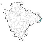
 This area comprises an elevated rolling ridge comprising discrete conical hills which extend into Dorset to the east and are associated with wooded slopes and lower lying valley farmland. Located at the south-east border of Devon, this area shows similarities with the Blackdown ridges to the west and north but has gentler, smoother topography and is lower lying with coastal influences. Its eastern boundary is marked by the county boundary with Dorset; to the south it is flanked by the Sidmouth and Lyme Bay Coastal Plateau and to the north and east by lower lying farmland within the Axe Valley.
 -
Constituent Landscape Character Types
Constituent LCTs: 1A: Open Upland Planned Plateaux, 2A: Steep Wooded Scarp Slopes, 3B: Lower Rolling Farmed and Settled Valley Slopes Part of NCA: 147: Blackdowns -
Distinctive Characteristics
- Elevated land with a rolling topography giving rise to rounded or conical shaped hills and steep wooded slopes, reflecting the underlying greensand geology and clay valleys.
- Landscape with streams and springs draining into the adjacent farmed valleys, with the Lim to the south being the principal valley within the area.
- Higher ground sparsely wooded with grown-out wind-sculpted beech hedgebanks and some pine shelterbelts.
- Steeper slopes are densely wooded – ancient oak with bluebells and primroses; beech-dominated woodlands and conifer plantations.
- Regular modern and Parliamentary fields of large and medium size on the ridges, reflecting late enclosure of common land on the hills.
- Contrasting smaller curving fields of medieval origin on valley slopes.
- Low narrow earthbanks with hedges on ridgetops; wider historic banks in the upper farmed valleys; more species-diverse Devon hedges (e.g. beech, sycamore, ash, hazel and gorse) with flower, fern and moss-rich banks on lower slopes.
- Mainly pasture (often improved) and dairy farming with some mixed farming on heavy brown soils.
- Remnant areas of ancient semi-natural and broadleaved woodlands on slopes.
- Semi-improved and unimproved neutral grassland and springline mires occurring mainly on the scarp slopes and in the upper farmed valleys.
- Villages clustered at road crossings e.g. Hawkschurch and Uplyme and the more recent development of Raymond’s Hill.
- Farmsteads scattered throughout, nestled in dips with beech shelterbelts.
- Straight roads with verges on narrow ridges across hills, descending abruptly to sinuous lanes tightly enclosed by close hedgebanks.
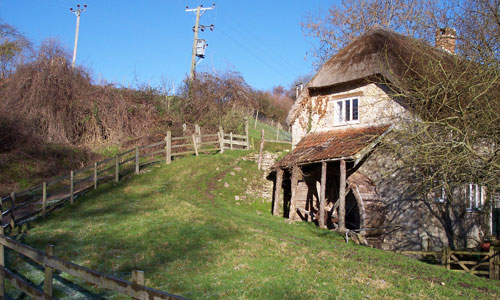
- Strong local vernacular of sandstone buildings with slate roofs and red brick detailing.
- Strong overarching perceptions of tranquillity and remoteness in many areas.
Evaluation
-
Special qualities and features:
- Distinctive, unspoilt, and exposed skylines.
- High scenic quality reflected in the inclusion of the southern part of the area in the East Devon AONB.
- Outstanding views across East Devon, mainly southwards to the coast but also northwards into the Blackdowns and across the Axe Valley.
- Bronze Age barrows in elevated positions on the ridges; setting to Lambert’s Castle (Iron Age hillfort adjacent, in Dorset) and Musbury Castle hillfort.
- Many CWSs designated for unimproved neutral grassland and broadleaved woodland; and SSSI designations at Lambert’s Castle, Park Farm Meadows and Bulmoor Pastures and Coppice.
- Notable areas of ancient semi-natural woodland in the north e.g. New Park Coppice.
- Contains the Monarch’s Way and East Devon Way long distance paths.
- Picturesque historic villages with traditional buildings linked by narrow winding lanes crossing historic stone bridges; many listed buildings.
Forces for Change and Their Landscape Implications:
-
Past and Current
- Past drainage of the watermeadows through the creation of ditches and planting of hedges resulting in a change to the open watery character of the floodplain.
- Lack of management and removal of hedgerows due to agricultural intensification.
- Growth of settlements (particularly Axminster where an industrial estate has altered the town’s nucleated form) affecting views up and down as well as across the valley.
- Intrusion from the A358 north of Axminster, where it runs along the valley sides and affects the quiet remoteness of area; and from the A35 Axminster by-pass which separates the town from the valley.
- Some areas of sand and gravel extraction on the valley floor and sewage works adjacent to settlements.
- Railway line travelling along the valley floor between Whitford northwards through Axminster and into Somerset.
- Depletion of mature tree and woodland stock due to historic loss of elm to Dutch Elm Disease.
- Decline in the number of orchards.
- Flailing of hedgerows to a ‘box’ shape has altered the lush, pastoral appearance of the landscape.
- Development of large farm buildings resulting in visual impact; and conversion of old farm buildings to dwellings altering character.
-
Future
- Potential loss of or change in oak- and beech-dominated valley woodlands due to spread of Phytophthora, intolerance of water level extremes and more frequent storm events.
- Uncertain future for the agricultural economy – levels of future agri-environment support and market prices for farmed products unknown.
- Development pressure within the area and along the B3165 and A35 corridors, particularly due to its attractiveness of the area as a place to live and new development at Rousdon Estate.
- Increased demand for wind turbines and communications masts on higher ground as well as for domestic and community-scale solar panels and small wind turbines, with cumulative impact on landscape.
Strategy
-
Overall Strategy:
[To protect the landscape’s distinctive, scenic rounded hills and the interrelationship between the open tops and the intimate, wooded valleys. Field patterns are reinforced through the restoration and management of distinctive hedgebanks. Scarp woodlands are managed and valley-side springline mires and wetlands are expanded to help prevent downstream flooding and protect water quality. The landscape’s time-depth continues to have a strong influence, whilst opportunities for sustainable recreation and limited low-carbon development are sensitively accommodated.
Guidelines:
-
Protect
- Protect the distinctive profile of the rounded hills.
- Protect the landscape’s strong sense of tranquillity and remoteness with clustered villages and hamlets reinforcing a strong historic sense of place.
- Protect the character and setting of Lambert’s Castle, ensuring any new development does not encroach into the historic landscape or views to it.
- Protect the sparse settlement pattern of clustered villages and farmsteads. Prevent the linear spread of development along river valleys and roads wherever possible, to maintain the settlements’ characteristic form and peaceful character.
- Protect traditional building styles and materials, particularly local chert with red brick detailing, utilising the same styles and materials in new development wherever possible (whilst seeking to incorporate sustainable design).
- Protect the landscape’s network of quiet lanes enclosed by woodland and species-rich hedgebanks, resisting unsympathetic highways improvements or signage.
-
Manage
- Manage conifer plantations for sustainable timber production, recreation and wildlife, creating new green links to surrounding semi-natural habitats.
- Manage and enhance the scarp semi-natural woodlands through traditional techniques including coppicing and control access by livestock to promote natural regeneration; explore opportunities for community utilisation of coppice residues as a low-carbon fuel source.
- Use extensive grazing to promote the species diversity of woodland ground flora.
- Manage the landscape’s distinctive beech hedges on higher ground to strengthen the strong square field pattern. Reinstate coppicing to mature sections and grown-out trees to ensure the future survival of these characteristic features.
- Respect the traditional methods and styles of construction, including stone facing on banks.
- Within the valleys, manage and extend species-rich mires and neutral grasslands through appropriate grazing and traditional land management regimes – both to enhance their wildlife value and function as flood prevention.
-
Plan
- Plan for long-term restoration of the more prominent conifer plantations and shelterbelts to semi-natural habitats (where their role in timber production has ceased) including re-creation of heathland on the hills and broadleaved woodland on valley slopes.
- Create, extend and link woodland and wetland habitats to enhance the water storage capacity of the landscape, reducing soil erosion, agricultural run-off and downstream flooding and improving water quality.
- Extend and link fragmented woodland sites through natural regeneration and new planting (using appropriate native climate-hardy species).
- Plan for increased tourism pressure, with coastal recreational management to the south, ensuring mitigation and management of honeypot sites.