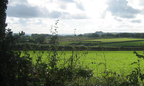
This landscape comprises a narrow, elevated, rolling ridge fringed by steep scarp slopes and upper valley farmland. The main ridge forms a distinctive spine to East Devon, fanning out into a series of narrow fingers that have distinctive southerly aspect and are flanked to the south by wooded slopes, which give way to small scale farmland in the upper and tributary valleys of the Axe and Sid. The northern finger of the ridge sits between the upper Otter valley and the Yarty valley. The river valleys drain southwards, forming steep sided and often remote-feeling valleys, whose sides are clothed with ancient oak woodlands. The Sid valley is the major landscape feature of the southern part of the area; further east the valleys are shorter, steeper and narrower. Views from the open upland ridges, particularly in the north, are extensive, often looking over the tree tops on the steep greensand scarps to other ridges beyond and into the visually strong field pattern of the valley slopes. The area is sparsely settled, with individual farmsteads and small hamlets in the valleys and vernacular buildings mainly of stone and red brick. Seen from the south, the area forms a backdrop to the valleys, separating the coastal plateau and Axe valley from the Blackdown Hills to the north.
-
Context
 This landscape shares many of the characteristics of the Blackdown Hills and is physically separated from that area by the upper Otter valley. It comprises a greensand ridge which forms a central spine to East Devon south of the A30 and Honiton. The north-western boundary of this area is marked by the abrupt wooded scarp overlooking the River Otter and Honiton. To the east there is a more gradual transition to lower lying farmland and the River Axe’s tributary valley the Yarty. To the south is a clear boundary with open plateau farmlands of the Sidmouth and Lyme Bay Coastal Plateau. To the north where the ridge narrows, the landscape becomes transitional with the Blackdown Hills and the boundary between the two areas, although difficult to perceive, is drawn along the Stockland Hill road.
 -
Constituent Landscape Character Types
Constituent LCTs: 1A: Open Inland Planned Plateaux, 2A: Steep Wooded Scarp Slopes, 3A: Upper Farmed and Wooded Valley Slopes Part of NCA: 147: Blackdowns -
Distinctive Characteristics
- Elevated narrow ridge with a rolling topography underlain by clay-with-flints or Upper Greensand.
- Landscape crossed by streams and springs draining into the adjacent steeply incised wooded valleys.
- Higher ground sparsely wooded with grown-out beech hedgebanks and some pine shelterbelts.
- Steep scarp slopes that are densely wooded – ancient oak with bluebells and primroses; and some conifer plantations which extend onto the ridges.
- Regular modern and Parliamentary fields of large and medium scale on the ridges, reflecting late enclosure of common land (e.g. Stockland Hill), contrasting with smaller curving fields of medieval origin on valley slopes.
- Low narrow earthbanks with hedges on the ridgetop, with wider historic banks in the upper farmed valleys and more species-diverse Devon hedges (e.g. beech, sycamore, ash, hazel and gorse) with flower, fern and moss-rich banks on lower slopes.
- Mainly pasture (often improved) and dairy farming with some mixed farming on heavy brown soils.
- Remnant areas of gorse, heathland and bracken on the ridges; ancient semi-natural and broadleaved woodlands on the scarp slopes; semi-improved and unimproved acidic and neutral grassland and springline mires occurring mainly on the scarp slope and in the upper farmed valleys.
- Bronze Age barrows in elevated positions on the ridges; hillfort sites on upper slopes of valleys; ancient settlement remains that also lend strong time-depth.
- Clustered hamlets and villages at road crossings with little 20th century development. Farmsteads scattered throughout, nestled in dips with beech shelterbelts.
- Straight roads with verges on ridges change abruptly to sinuous lanes defined tightly by close hedgebanks, with steep decents.
- Very distinctive building tradition that uses local cherts (flint-like nodules occurring occurs within greensand) with red brick detailing and slate roofs.
- Strong overarching perceptions of tranquillity and remoteness in many areas.
Evaluation
-
Special Qualities and Features:
- Distinctive, unspoilt, and very exposed skylines.
- High scenic quality reflected in the north half of the area forming part of the Blackdown Hills AONB and the southern half part of the East Devon AONB.
- Outstanding views across East Devon, mainly southwards to the coast but also northwards into the Blackdowns.
- Sense of isolation, tranquillity and remoteness, enhanced by natural qualities of the rivers and scarp woodlands.
- Many CWS sites comprising ancient semi-natural woodland; semi-improved and improved acidic and neutral grasslands; springline mires; and extensive areas of heathland and gorse scrub particularly on Gittisham Hill and Broad Down and Dumpton Hill.
- Prominent Bronze Age barrows on Grittisham Hill and Farway Hill; earthwork remains of former castles e.g. Stockland Little Castle, Stockland Great Castle and Farway Castle hillforts.
- Combe House Registered Park and Garden, including historic wood pasture and parkland.
- Picturesque villages with traditional buildings linked by narrow winding lanes crossing historic stone bridges; many listed buildings.
Forces for Change and Their Landscape Implications:
-
Past and Current
- Past planting of small coniferous plantations forming conspicuous features on higher ground and blurring the distinction between open ridge and steep wooded scarps.
- Decline in woodland management including coppicing, and a spread of non-native species affecting the appearance and biodiversity of the landscape’s woodlands.
- Hedgerow removal in the drive for agricultural intensification; replacement with post-and-wire fencing, affecting the integrity of field patterns.
- Lack of hedgerow management (laying and coppicing) leading to grown out sections of beech, now susceptible to windthrow and storm damage.
- Conversion of former areas of moorland to pasture, beginning in the late 18th century and intensifying after the Second World War.
- Recent lack of grazing on land on ridgetop edges and steep valley sides, leading to a spread of gorse and bracken.
- Prominent telecommunications masts on Gittisham Hill and television transmitter at Stockland Hill.
- Growing demand for facilities such as caravan parks, holiday accommodation, golf courses and visitor attractions – many as farm diversification enterprises.
- Recreation pressures and growing traffic levels on rural roads, particularly at holiday time.
- Heavy farm traffic leading to vehicular damage to roadside hedges and woodland.
- Removal of vegetation by Highways Authority leading to a change in character of roads.
- Peace and tranquillity interrupted by main roads radiating from Honiton that transect the area i.e. the A375, A35 and A30.
-
Future
- Increase in the area of coniferous plantation and woodland planted to filter water, minimise downstream flooding, store carbon and provide low carbon fuel (through coppice management).
- Potential loss of or change in oak- and beech-dominated valley woodlands due to spread of Phytophthora, intolerance of water level extremes and more frequent storm events.
- Uncertain future for the agricultural economy – levels of future agri-environment support and market prices for farmed products unknown.
- Longer growing season and faster growth of bracken, gorse and secondary woodland resulting in a decrease in remaining areas of heathland and rush pasture.
- More intense periods of drought, as a result of climate change, leading to the drying out of important wetlands including spring line mires and rush pasture.
- Increased autumn and winter precipitation leading to higher water levels and consequent increases in poaching of river banks and flood risk in lower catchments.
- Development pressure within the area and along the main A375 corridor and north of Sidmouth, particularly due to its attractiveness of the area as a place to live.
- Increased demand for wind turbines and communications masts on higher ground as well as for domestic and community-scale solar panels and small wind turbines, with cumulative impact on landscape.
- Uncertainty over future agri-environment scheme funding putting conservation of species-rich grasslands and heaths at risk.
Strategy
-
Overall Strategy
To protect the distinctive and highly scenic interrelationship of narrow ridge, wooded scarp and intimate upland valley. Opportunities are sought to restore conifer plantations to broadleaved and heathland habitats reinforcing the distinction between the landscape types that make up this area and strengthening the network of valuable heathland habitat. Field patterns are reinforced through the restoration and management of distinctive hedgebanks. Scarp woodlands are managed and valley side wetlands expanded to help prevent downstream flooding and protect water quality. The landscape’s time-depth continues to have a strong influence, whilst opportunities for sustainable recreation and limited low-carbon development are sensitively accommodated. The peaceful and historic character of the valley settlements is enhanced whilst providing recreational spaces in less prominent locations.
Guidelines:
-
Protect
- Protect the distinctive, unspoilt, and exposed skylines of the central spine and its outstanding views across East Devon.
- Protect and appropriately manage the rich cultural heritage of the area’s hilltops, such as Bronze Age barrows, hillforts, through livestock grazing at appropriate levels and recreation management.
- Protect the character and setting of Combe House park and garden, ensuring any new development does not encroach into the historic landscape or views to it.
- Protect the sparse settlement pattern of clustered hamlets, villages and farmsteads maintaining the settlements’ characteristic form and peaceful character.
- Protect traditional building styles and materials, particularly local chert with red brick detailing, utilising the same styles and materials in new development wherever possible (whilst seeking to incorporate sustainable design).
- Protect the landscape’s network of quiet lanes enclosed by woodland and species-rich hedgebanks, resisting unsympathetic highways improvements or signage.
-
Manage
- Manage and enhance the scarp semi-natural woodlands through traditional techniques including coppicing and control access by livestock to promote natural regeneration. Explore opportunities for community utilisation of coppice residues as a low-carbon fuel source.
- Use extensive grazing to promote the species diversity of woodland ground flora.
- Manage the landscape’s distinctive beech hedges on higher ground to strengthen the strong square field pattern. Reinstate coppicing to mature sections and grown-out trees to ensure the future survival of these characteristic features.
- Respect the traditional methods and styles of construction, including stone facing on banks.
- Within the valleys, manage and extend species-rich mires and neutral and acidic grasslands through appropriate grazing and traditional land management regimes – both to enhance their wildlife value and functions in flood prevention.
- Manage heathlands and acidic grasslands on hills such as Dumpton by appropriate grazing and other works to control scrub and bracken.
-
Plan
- Plan for long-term restoration of the more prominent conifer plantations and shelterbelts to semi-natural habitats (where their role in timber production has ceased) including re-creation of heathland on the ridges and broadleaved woodland on steep scarp slopes.
- Create, extend and link woodland and wetland habitats to enhance the water storage capacity of the landscape, reducing soil erosion, agricultural run-off and downstream flooding and improving water quality.
- Extend and link fragmented woodland sites through natural regeneration and new planting (using appropriate native climate-hardy species).