
Between 2016 and 2018 an archaeological aerial investigation, centred on the distinctive protected landscape of the Blackdown Hills Area of Outstanding Natural Beauty, was undertaken by a project team of staff from AC archaeology and Devon County Council. It was funded by Historic England and hosted by Devon County Council within the Historic Environment Team in partnership with Somerset HER.
Read more about similar projects in Devon (formerly called ‘National Mapping Programme’ or ‘NMP’).
The survey area covered 564 square kilometres in Devon and Somerset, focused around the AONB, which has seen little systematic archaeological survey and where the archaeological resource was relatively poorly understood. In addition the Historic Environment is under pressure from potential impacts as diverse as initiatives to reduce diffuse water pollution to road improvement schemes.
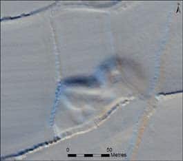
The project consulted over seven thousand hard copy aerial photographs loaned from the Historic England Archive and held by Devon County Council, as well as modern digital datasets of vertical aerial photographs. However it was the remote sensing technique known as lidar that proved to be exceptionally useful during this project, enabling features obscured by tree cover and those that survived only as slight earthwork remains to be mapped and recorded.
In total, 5052 archaeological or historic sites were identified from the aerial imagery and recorded on the relevant Historic Environment Record (HER); 87% of these had not previously been recorded.
A number of different ‘themes’ became apparent as the project progressed. These are summarised below, but much more detail is available in the report accessible from this Historic England webpage. The individual monument records are all available online via either the Somerset HER, or the Devon Environment Viewer and Heritage Gateway.
It’s the Pits!
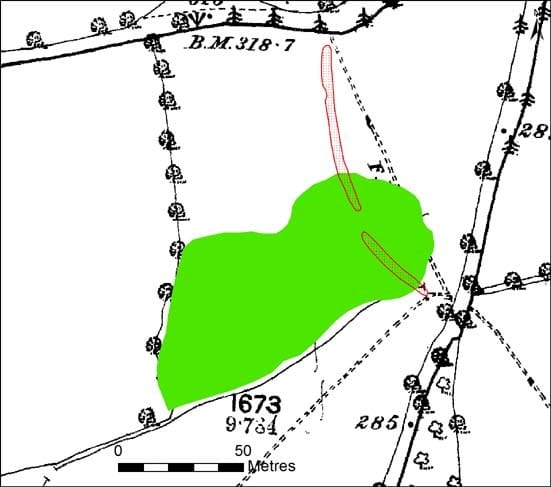
Surprisingly, by far the most numerous type of monument were extractive pits, which made up over a third of all features recorded! Although this doesn’t at first sound particularly thrilling, these unprepossessing features make a huge contribution to the distinctive landscape of the AONB. They became wooded, sometimes by deliberate planting of orchard trees, producing the many small tree clumps that dot the hills.
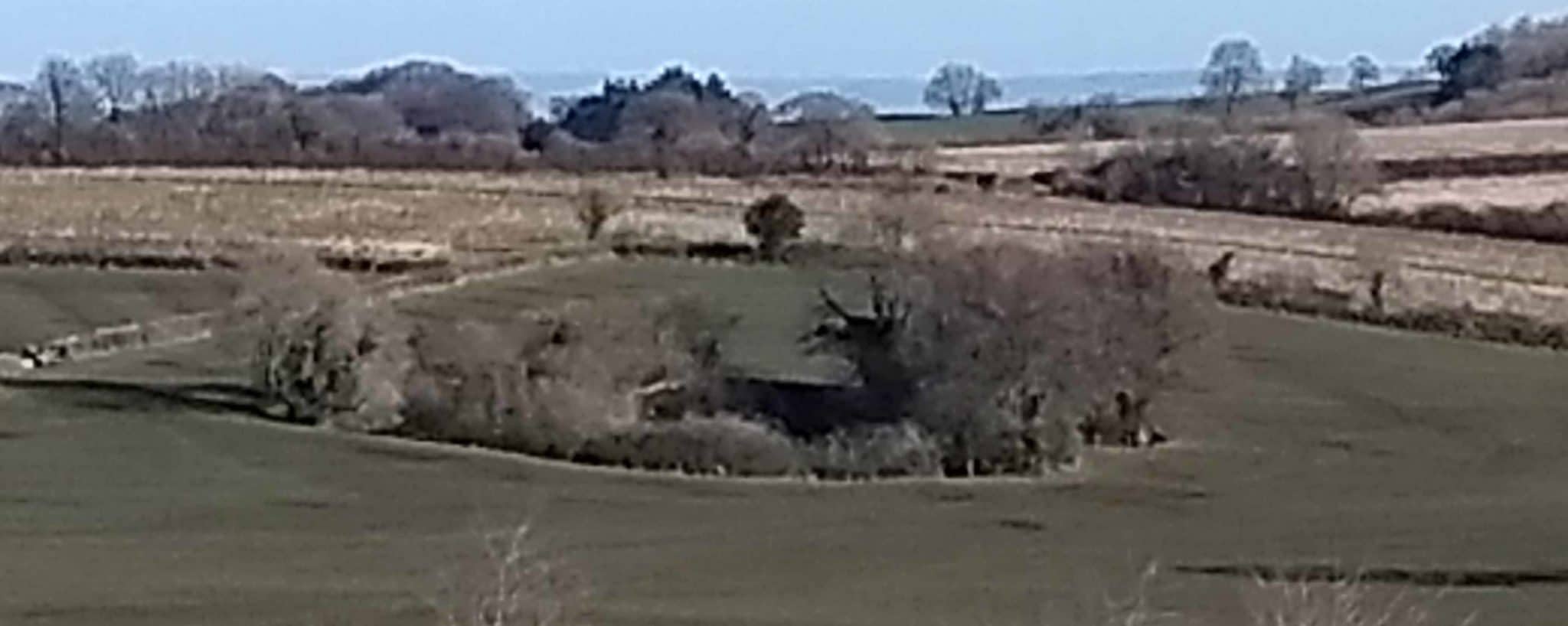
These scattered pits were for extraction of clay, marl, gravel, chalk and sand, reflecting the varied geology of the project area. Although difficult to date, the size and definition of the earthwork, type of vegetation cover, comparison with historic maps, field patterns, field names and other evidence can help to infer the date of use. Some pits may originate in the medieval period, whilst others were in use right up to the 20th century. Many of the gravel pits for instance might have been associated with improvements to roads in the 18th and 19th century, whilst chalk pits are often seen in conjunction with lime kilns of similar date, having been used to produce agricultural lime.
As expected, clay pits tended to be concentrated around places that produced ceramics such as Donyatt or Hemyock. Some of these pits may well date back to the medieval period when we know that the industry was already established in these areas, and newly recorded pits north of Honiton suggest a similar pattern at that pottery production centre. Marl pits were more frequently recorded, reflecting farmers’ desire to improve the land through ‘marling’ (mixing certain clays with lighter soils to decrease acidity and improve structure). Known in the medieval period, map evidence indicates continuation through to the modern era, and some of the very largest pits may have been created by periodic use over several generations. It is also possible that marlpits supplied materials for traditional cob buildings.
We frequently had no convincing evidence for what material was extracted, so many are recorded simply as ‘extractive pit’, and not even historic maps could provide credible indications, given that different types of pit were often marked in very close proximity. However, some clues could be gleaned from the underlying geology, or other indications such as proximity to a road; a pit in the centre of a field is more likely to have been for local agricultural improvement than for ongoing transport.
The scattered and often small-scale pits form a marked contrast to the much more intensive Roman-medieval iron ore and 18th-20th century whetstone mining industries on the western part of the AONB (you can read more about these here).
Changing Fieldscapes
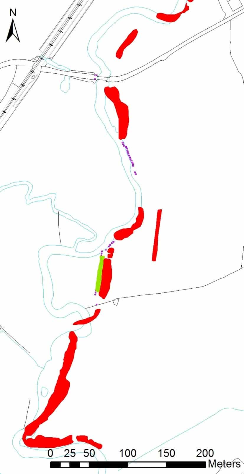
Relict or removed field boundaries were the second most numerous monument type recorded during the survey, at a fifth of the total. Many have a curvilinear form, enclosing small and irregularly shaped fields, which suggests a medieval origin. A high proportion were seen in areas recorded by Historic Landscape Characterisation as medieval enclosures, presumably having gone out of use during later land reorganisation and field amalgamation.
About 80% of the removed boundaries were recorded as earthworks, some of them very wide shallow ditches suggesting that there may have been substantial drainage banks associated with them in certain areas. Only an eighth were visible just as cropmarks, testament to the generally good survival of earthwork remains within the project area.
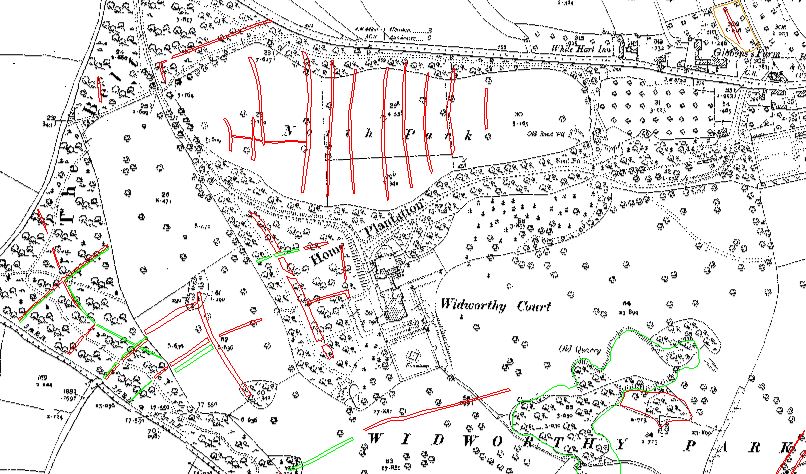
The variety of remains is diverse, from the irregular possible squatters’ temporary intake at Hense Moor to more extensive field systems and lost settlement at Luppit, and typical curvilinear strip field patterns at Widworthy Park. A number of other post-medieval parklands also displayed evidence of earlier fields, which perhaps went out of use when the land was emparked, e.g. Henlade House (Somerset). Remains of medieval deer park pales could also be distinguished as massive boundaries on lidar-derived images, for instance at Poundisford Park.
Less extensive field boundaries, but possible infields, trackways and building plots were mapped at deserted settlements such as City of Ford and newly recorded sites such as the shrunken settlement at Regency House.
Other medieval landscape features that are preserved as earthworks are the early routeways that criss-crossed the landscape before enclosure and turnpikes started to regularise the road network. Sometimes these can leave extensive remains; for instance near Turbury Cross a number of interlacing trackways have been mapped, and over 3km of trackway is visible running north-east from Cotleigh Crossing. Elsewhere, former roads complement records of deserted settlements, such as at Playstreet (Somerset).
Even earlier features might also have been observed; fragments of possible Roman Road were also spotted in various places along the route of the Fosse Way.
A small proportion of enclosures were assigned a probable later-prehistoric date, and although important archaeologically, these features do not seem to have made a significant impact on the current landscape.
(More) Cider Making

Although not quite as numerous as in the East and Mid Devon project, parallel rows of tree planting banks for cider orchards were still very often visible in the more poorly draining mudstone areas.
As well as assisting with drainage, these increased the soil depth and could be augmented with other helpful inclusions, such as sand and road scrapings known as ‘waydrift’.
Some of these orchards seem to have been long-lived, attributed by Marshall in 1796 to the Devonshire practise of replanting in between failed trees and so helping to avoid disease. Another interesting arboricultural technique was noted by Vancouver a few years later: ‘It is usual … to appropriate for orchards the large excavations formerly made in digging marl’.
This provided shelter for the fruit trees, and neatly explains the very high preponderance of orchard banks that were visible in disused pits!
A more exposed orchard might have been established in another unusual location, giving rise to the interesting suggestion that 18th or 19th century cider was produced from apples grown within the Iron Age hillfort at Membury.
Fortification and Control
Some of the earliest defended sites visible on aerial imagery were the Iron Age hillforts at prominent sites such as Hembury, and the mapping of their ramparts and ditches, as well as some internal features, emphasises just how imposing these sites must have been.
More intriguingly, three rectilinear features were recorded on the lower slopes of the Blackdown Hills overlooking tributaries of the River Axe, within a few kilometers of the Axminster to Honiton Roman road. These were tentatively interpreted as Roman forts, although subsequent geophysical survey at two of the sites did not provide any supporting evidence for this and they remain, for the moment, enigmatic!
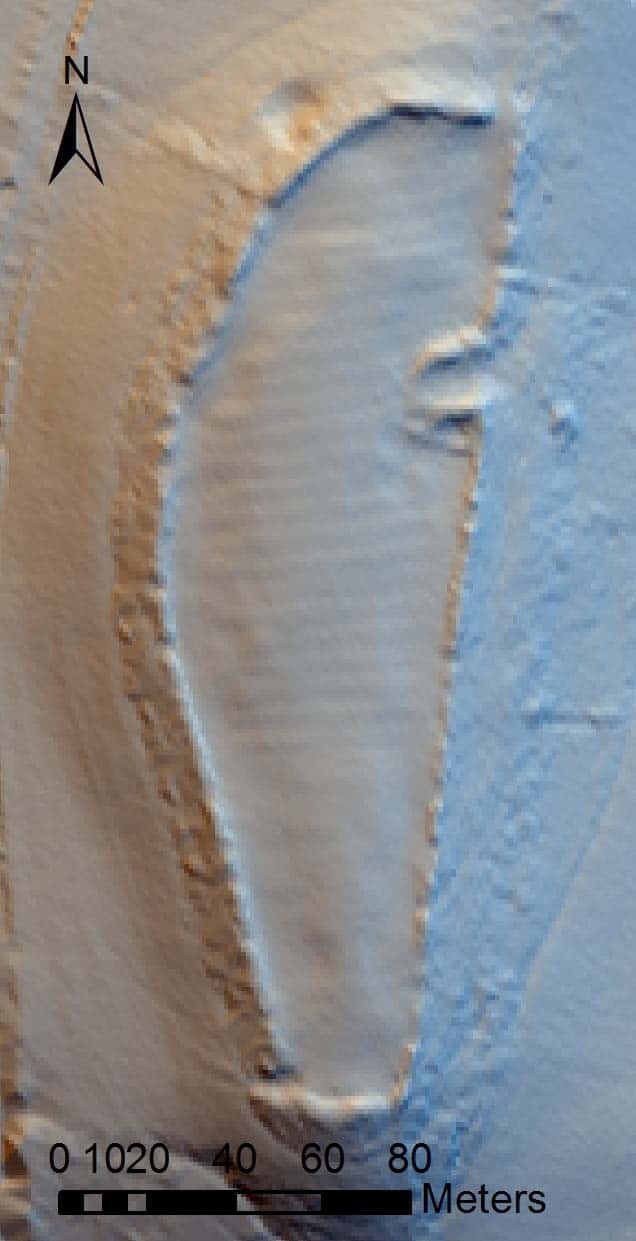
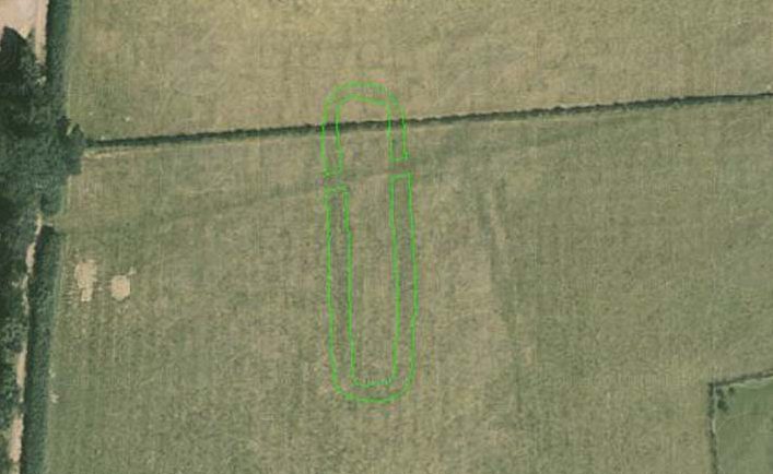
Medieval defended sites are relatively rare, but alongside well-known places like the imposing Castle Neroche (Somerset), examination of recent lidar data seems to confirm that three small motte and bailey castles were sited at Widworthy, Bushy Knap and Buckerell Knap.
In the early years of the Second World War the eastern part of the project area became a particular focus of activity as invasion seemed increasingly likely. One of several defensive lines in the UK, the Taunton Stop Line ran across the narrowest part of the south-west peninsula and was intended to slow an enemy advancing from the west.
Many of the defences survive, and many more could be seen on the aerial photographs, particularly substantial anti-tank ditches, structural features such as gun emplacements and a large number of anti-tank blocks. Most of these were already known, but one interesting and newly-recorded type of defensive work was identified; extensive riverside banks alongside the River Axe and River Isle. Two sisters living in Axminster recall that the Yarty and Axe were dredged as part of the anti-invasion preparations, the silt having been used to bank up the sides. Similar efforts to steepen existing defences could be seen for example along the Chard Canal in Somerset. The sisters also remember how the anti-tank ditches made good places to swim on hot summer days!
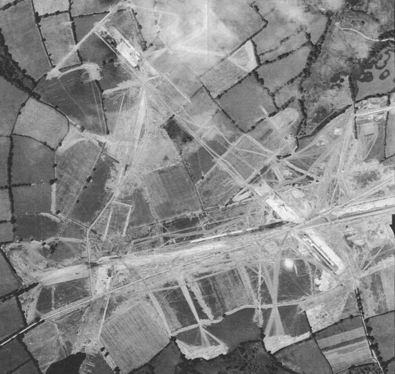
However this wasn’t the only landscape in the project area that was significantly altered by military activity in the 20th century; the flat plateaux of the Blackdown Hills and proximity to the Atlantic and English Channel made this a highly suitable location for airfields. Personnel was varied, with Polish and Czech squadrons at RAF Culmhead and RAF Dunkeswell handed over to the US Navy. RAF Upottery and RAF Merryfield were constructed in preparation for the invasion of Europe and allocated to the US Air Force, and it is fascinating to see these in the process of construction or use on the 1940s aerial photographs.
Later in the conflict, different types of military structure were required, and the US military hospital at Millwey Rise was constructed to treat soldiers wounded during the D-Day landings. Its layout is clearly visible on the aerial imagery and becomes fossilised in the subsequent street plan, so it is still possible to walk along the same routes as the American GIs. ‘The Camp’ is mentioned in oral histories by some of the Axminster Remembers participants, including dances held there, and a visit from Jimmy Cagney!
Religion and Ceremony
Neolithic ceremonial or funerary monuments are rare, so we were excited to add this new site to the HER: a possible long barrow at Broadhembury, which was first recognised from cropmarks on aerial photographs taken in 1989.
More frequently observed were indications of the more familiar circular Bronze Age barrows, particularly on the prominent greensand plateau. A number of additional examples were added, not just to known cemeteries such as Robin Hood’s Butts but also potential ‘new’ clusters, eg at Hartridge.
Well-known sites such as Dunkeswell Abbey also benefit from the in-depth study of aerial imagery, and in this instance lidar was again crucial in mapping subtle features within the inner precinct that might relate to provisioning – perhaps a dovecote or stewpond, and other ancillary structures. Parchmarks of the east range, that had been noted since the 19th century, could finally be accurately plotted from aerial photographs taken in 1989. It is possible that the exact site of the monastic grange of Bowerhayes has also now been identified.
Your Comments
Would you like to share additional information on any of the sites we recorded from aerial photographs, or do you have a different interpretation? Let us know! We read all submissions but unfortunately due to the volume of responses we are unable to respond personally to every comment.
Further Reading
Dawson, D., Hunt, D. & Webster, C. 2011 Somerset and the Defence of the Bristol Channel in the Second World War. Somerset Archaeological and Natural History Society: Taunton.
Hegarty, C., Knight, S. & Sims, R. 2018 The Blackdown Hills Area of Natural Beauty: The Blackdown Hills AONB and East Devon River Catchments Aerial Investigation and Mapping Survey. Historic England Research Department Report 24/2018.
Historic England. 2015. Using Aerial Photographs
Hunt, A. 2000 ‘An Earthwork Survey of Dunkeswell Abbey’. Proceedings of the Devon Archaeological Society 58, 215-226
Marshall, W. 1796 The Rural Economy of the West of England, Volume 1. David & Charles: Newton Abbot, 1970 reprint.
Silvester, R.J. 1980 ‘An Excavation at Dunkeswell’. Proceedings of the Devon Archaeological Society 38, 53-66.
Sturch, D. 2017 Rhymes of Life 1947-1952 The Camp (Millway Rise). Derek Sturch
Turner, S. 2007. Ancient County: The Historic Character of Rural Devon. Exeter: Devon Archaeological Society Occasional Paper 20.
Vancouver, C. 1808 General View of the Agriculture of the County of Devon with observations on the Means of its Improvement Drawn up for the Consideration of the Board of Agriculture and Internal Improvement. London: McMillan.
Wilson, D. 1982. Air Photo Interpretation for Archaeologists. London: Batsford.