As the Lead Local Flood Authority, we are committed to the delivery of flood improvement works to vulnerable communities in Devon.
COVID-19 Update on Flood Improvement Schemes – Updated 21st August 2020
All projects have been delayed due to the COVID-19 pandemic. Site works were demobilised and design teams disrupted as a result of home working and restricted access to design software. However, works are now resuming with safe working methods in line with Government guidance.
In partnership with other risk management authorities such as district councils, the Environment Agency, South West Water and Devon Highways, we look for synergies and overlaps in order to ensure that flood risk is investigated and resolved in a coordinated manner where possible.
Where a flood risk has been identified, we work with our consultants and design teams to investigate, optioneer and promote effective options that fit within achievable funding opportunities. Depending on the source and extent of flood risk, the options and form of new defences can vary. These range from ‘hard’ engineering measures such as new culverts, flood relief channels, flood walls and embankments, to ‘soft’ engineering measures, known as Natural Flood Management. These Natural Flood Management techniques aim to slow the flow in the upper catchments such as woody debris dams, field buffer strips and soil management. These more natural measures can stand alone, or support and enhance a hard engineering scheme. Where significant improvements cannot be installed, properties at risk can be supplied with Property Flood Resilience measures such as flood doors, boards, airbrick covers and non-return valves in order to limit the impact of flood water coming into contact with the building.
Funding for flood risk management schemes can be obtained from various sources, these include Devon’s allocated budget toward flood improvement measures, the Regional Flood and Coastal Committee administered Local Levy pot, contributions from other Risk Management Authorities, private contributions from local businesses/property owners benefitting from the scheme and Flood Defence Grant in Aid funding allocated by HM Treasury and administered by the Environment Agency. The current national funding mechanism stipulates the requirement of partnership funding toward Flood Defence Grant in Aid funded works; and as part of the role DCC perform, we will approach affected stakeholders in order to coordinate contributions and produce business case documents to support flood defence scheme applications.
As part of the Local Flood Risk Management Strategy, each year DCC allocate funding to support flood scheme development and delivery throughout the County, forming part of the Action Plan approved by cabinet members. This gives authority for money to be spent in those locations deemed high priority and most at risk as well as give the flexibility to promote works in a location where the opportunity arises.
Flood Risk Management Schemes
Devon County Council are continuing to deliver the schemes prioritised in the Annual Flood Risk Management Action Plan. Many schemes are ongoing and will continue to be delivered through 2020/21, subject to contractor availability and safe working practices as a result of the Covid-19 pandemic. See below for an update on the progress of various schemes:
Achievements in Flood Risk Management in 2019/20 – updated 02/06/20 to reflect effects of pandemic
Achievements in Flood Risk Management in 2018/19
Current flood schemes
DCC has an input in flood schemes over a number of locations throughout the County. This includes contributions to works by others, investigations and physical improvement works. All of DCCs current schemes and their progress can be viewed on the DCC Environment Viewer interactive map. Individual case studies can be accessed below.
-
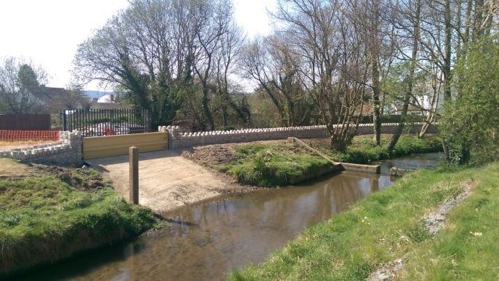
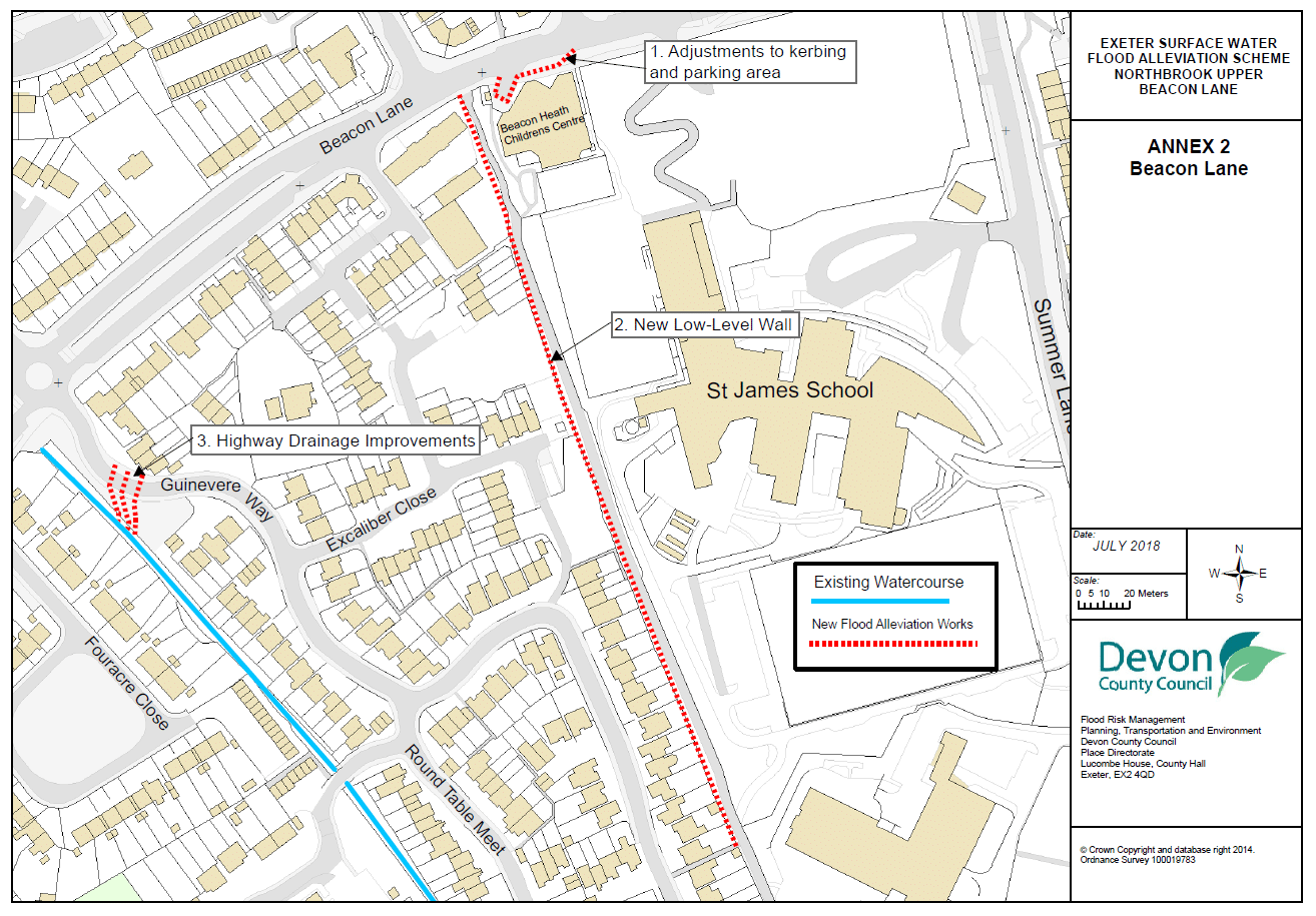
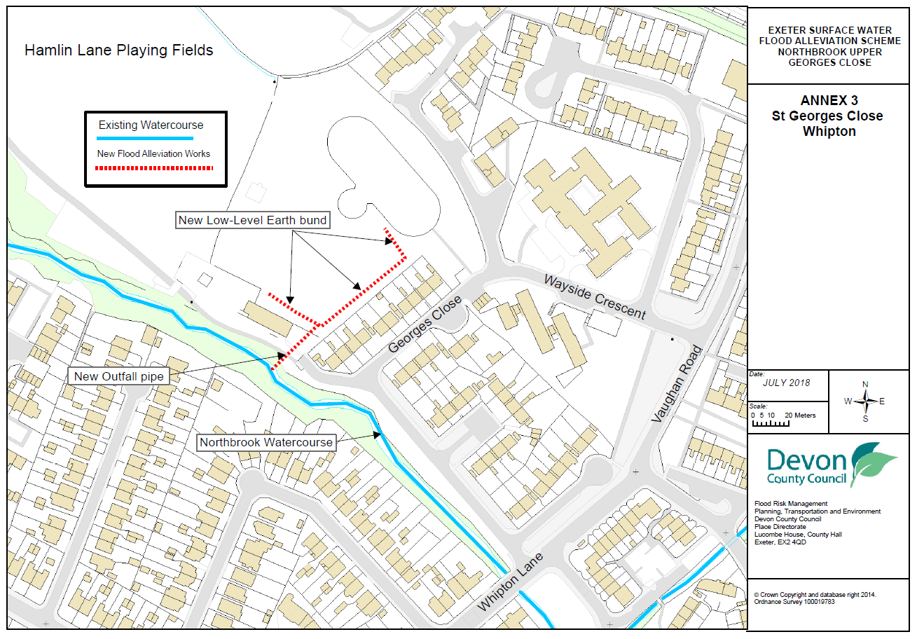
Exeter Northbrook
Devon County Council, working with partners Exeter City Council, South West Water, Network Rail and the Environment Agency produced a Surface Water Management Plan (SWMP) document for Exeter. The SWMP identified those areas in the City that were at greatest risk of flooding from surface water and ordinary water courses. The study identified that areas in Beacon Heath and Whipton were at significant rick of flooding. Subsequently DCC has been promoting works in these areas that will look to give betterment to 50 residential properties.
The delivery of the Northbrook upper scheme will take place in two phases over between spring 2019 and summer 2020.
Phase 1- Five linear drainage channels will be installed to capture surface water flows and discharge into the Northbrook watercourse in the Guinevere Way area of Beacon Heath at a restricted rate so as not to increase flood risk downstream. Work will also take place along the footpath to the west of St James School to capture and deflect surface water flows from surrounding roads in the area away from residential properties.

Phase 2- South of the railway in Hamlin Lane Playing fields an above ground water storage area will be created, to attenuate predicted surface water flows in the area to reduce the risk of flooding. This bund will discharge back into the drainage system and into the watercourse at a controlled rate.

August Update
The surface water flood improvements adjacent to George’s Close, which will benefit 20 properties had been delayed due to the pandemic, however tenders are due in Friday the 17th of August with a start date of the 1st week of September being worked toward.
-
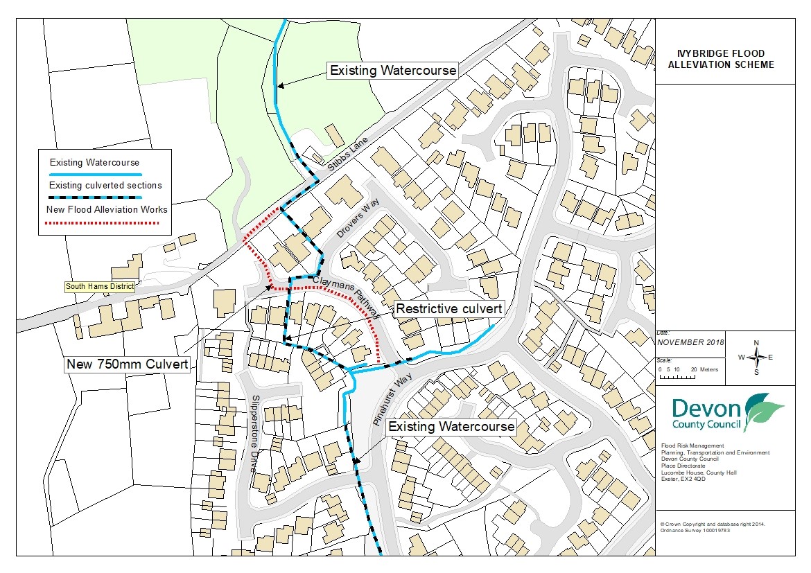
Ivybridge, Stibbs Lane
Following the repeated flooding in the Woodlands area of Ivybridge since 2012 South Hams District Council investigated the source of flooding and the potential solutions to alleviate it. Following the retirement of the SHDC engineer the scheme was passed to DCC to progress and deliver.
The flood alleviation works aim to convey overland flood flows downstream of the area at risk of flooding in order to significantly reduce the flood risk to 76 residential properties and have been estimated to cost in the region of £650,000.
This will be achieved by a combination of Natural Flood Management (NFM) and traditional defences. The NFM elements of the scheme are located at Hanger Down 1km north of the area that will benefit. A cascade of leaky dams will be installed in a ditch that becomes the means of conveying water during extreme rainfall. The leaky dams will slow and store this flow to reduce the impact downstream. This part of the work is being undertaken in conjunction with the Environment Agency and the Dartmoor Headwaters Project.
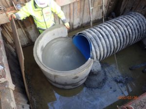
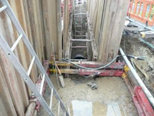
In addition to this the existing culverted watercourse system through Ivybridge will be upsized by installing a 130m long 750mm diameter culvert going from Stibbs Lane down through the residential area of Claymans Pathway and Slipperstone Drive to discharge into an existing watercourse to the south.
A new swale has already been constructed in Woodlands Park to the south in order to intercept out of bank flows from the local watercourse and surface water locally.
The work will be funded by Devon County Council, SHDC, Local Levy and Flood Risk Grant in Aid and is due to be completed in the winter of 2019.

August Update
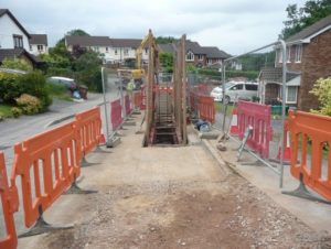
Although the construction of the flood improvements at Ivybridge was significantly delayed due to the pandemic. Works have now resumed on site and are making good progress. The contractor has revised their working methodologies to ensure they are adhering to government guidance following social distancing rules. The works are due to be completed in Sept 2020.
The Natural Flood Management works proposed in the upper catchment are to be progressed in the summer months subject to contractor availability.


-
Frogmore
Working with the local parish council, a scheme has been developed following flooding that occurred during the winter of 2012/13 in which overland runoff of silt-ladened water flooded 12 properties internally. The whole scheme includes several elements of re-directing surface water run-off.
Phase 1 involved the installation of a large drainage grid which collects surface water and discharges under the highway through a new culvert. The construction of the new culvert running under the A379 was completed in February 2019 and will discharge surface water directly into the Salcombe and Kingsbridge estuary just south of the highway. Designs had to go through Natural England for approval since the Salcombe and Kingsbridge estuary is a designates Site of Special Scientific Interest.
Phase 2 is due to be carried out during the summer of 2021 and will involve directing the flow of water into the newly installed drainage grid from the above fields and working with landowners and the local community.

-
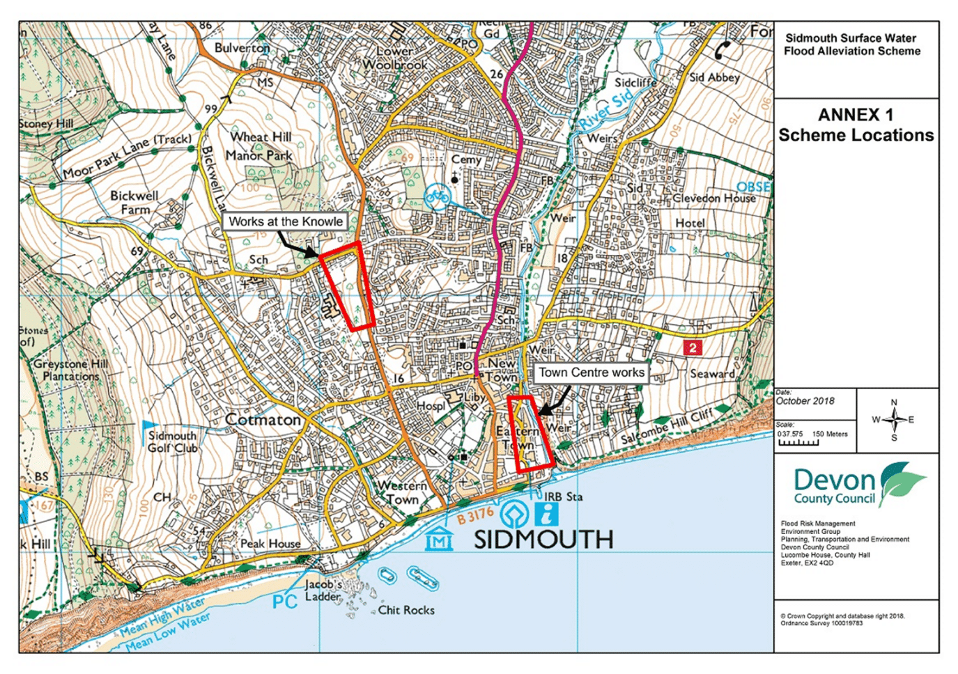
Sidmouth
Following a Surface Water Management Plan (SWMP) produced by DCC in partnership with East Devon District Council, South West Water and the Environment Agency, a scheme has been developed that will improve the standard to flood protection from surface water to over 100 residential and commercial properties.

Linear drainage channels will also be installed at Station Road and Broadway junction collecting the overland flows from this area. These channels will discharge into a bunded storage area within The Knowle grounds. Water will be discharged from the bund and into the drainage system at a controlled rate so not to increase risk downstream.
August Update
Planning permission has been approved for the flood attenuation at the Knowle, which includes the amphitheatre as part of the storage and landscaping proposal to better protect 64 properties.
The contractor has been appointed and works are due to commence on Monday the 17th of August.
Once constructed the scheme will not only give the desired flood benefit, but also be an amenity space for the community to enjoy.

Further drainage improvements in the Town Centre are currently being developed for delivery in the 21/22 financial year.
-
Property Level Resilience (PFR)
Cullompton PFR – Works have now recommenced with the provision of PFR measures to 18 properties. Working methods have been agreed with each property owner to ensure they are happy for the PFR contractor to continue working on their property.
South Pool PFR – Tenders are due back at the beginning of July, so once a contractor is appointed works can continue through the final summer months.
DCC’s PFR Funding Scheme – Surveys have been completed and received for 3 new individual properties under this scheme. The owners of these properties will now source a contractor to deliver the PFR measures funded by this DCC/FDGiA/Local Levy project. The scheme will continue to be available for property owners to request financial support for the installation of PFR measure to make their properties more resilient to flooding.

Historic case studies
-
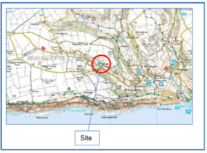
Branscombe Case Study
 The Street area of Branscombe is a small rural community situated 15 miles east of Exeter in East Devon. The natural topography for the area is such that the catchment has a long and narrow appearance which runs in a northwest / southeast direction and is approximately 1.8km2. The catchment elevation ranges from 170m AOD at its northern most point to less than 75m AOD in the village to the south. The site is flanked on both sides by steep slopes which converge on to the Street area of Branscombe
The main flood risk for Street originates from the large quantities of surface water run-off from higher ground; the primary flow route originates from the fields onto the highway and into Street. There are 20 residential properties at risk of flooding in Street and one public house which is key to the community.
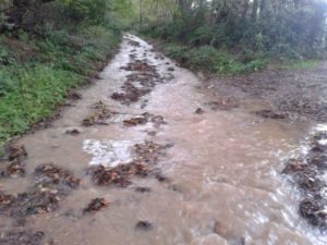
The Street area of Branscombe has been repeatedly flooded in the last 5 years resulting in properties being flooded internally. Flood events in 2012 resulted in seven properties suffering internal flooding on three separate occasions. This has placed the Street area of Branscombe in the top five of locations that Devon County Council Flood Risk Management (DCC FRM) are investigating to reduce the level of flood risk.

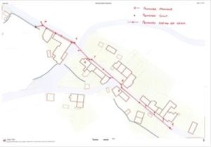
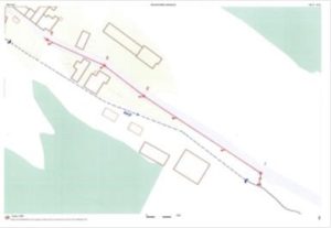
Flow Paths 
Flooding Following the flooding DCC FRM worked closely with the Environment Agencies’ East Devon, Land and Water Team to explore the possibilities to reduce the flood risk to the area. The resultant scheme devised by DCC FRM incorporates the installation of a new 450mm/525mm flood relief culvert through the village centre as well as land owner engagement upstream to improve farming and land management techniques.
The scheme has been estimated at approximately £180,000 inclusive of contingency and risk with the potential benefits calculated to £900,000 using the Multi Coloured Handbook. The scheme will be part funded with a £25,000 contribution from DCC Highways and a £70,000 contribution from DCC Flood Risk Management as the Lead Local Flood Authority. A Project Appraisal Report produced in house by DCC FRM was developed to successfully gain almost £85,000 Flood Defence Grant in Aid (FDGiA) through the Medium-Term Plan.

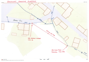
Holmcourt Diversion Proposals include the creation of a diversion pipe behind Holmcourt; this will intercept flows running down Berry Hill and pass the water downstream of residential property.
The project was initially scheduled to be commenced in the 2015/2016 financial year but was accelerated in its timescale due to the opportunity arising to share a road closure with the South West Water clean water team who were replacing a water main to the north of Street. This opportunity will not only save costs but minimise disruption to the residents. Otherwise two back to back road closures will be required with the potential disruption for over six months of consecutive engineering works.
The contractor is engaged and a road closure is in place for a start date in mid-November.
DCC FRM is committed to this project and views it as a good example of partnership working for the delivery of a scheme which will give a real world benefit to a rural community which suffers from internal flooding on a regular basis.
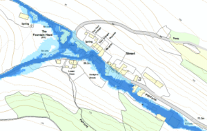
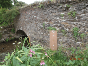
Fountain Head Flood Relief Culvert 
Fountain Head Flood Relief Culvert -
Luton, Broadhembury Parish – Community Flood Scheme
Luton, Broadhembury Parish – Community Flood Scheme Case Study
Luton is a small Hamlet in the Parish of Broadhembury in East Devon. It sits alongside an unnamed ordinary watercourse, which eventually flows down to the Main River Tale. Due to the local topography of the surrounding fields and roads that lead down to Luton, it is particularly vulnerable to surface water flooding.
Surface water on Wilderness Lane before the flood scheme. Luton has been threatened by surface water flooding in recent years, with the nearby roads, gardens and driveways flooded and in one case a near miss to property. It was found that after heavy rainfall these flows were generated in Wilderness Lane, where surface runoff from surrounding fields contributed to flows along the road, eroding and damaging the surface. Flows would then continue down the A373 towards Luton and across fields, following the topography down to nearby gardens and houses of Luton to collect in a large ‘lake’ in the field. Further flows also found their way down other pathways and tracks into Luton.
Following the flooding in Luton during the heavy rainfall and storms of February 2014, the local community decided to take action and to work together and in partnership with Devon County Council to put measures in place to reduce the flood risk.
The resulting flood alleviation scheme was developed and designed by local residents and supported by local land owners.
Phase 1 of the scheme is designed to divert surface water that was running down Wilderness Lane through a newly installed pipe and into the watercourse before it can travel down the main road and into Luton.
Phase 2 diverts water in another location across locally owned fields and into the river to the North East of Haskins Farm.
It is believed that the scheme will divert approximately 70-80% of the surface water into the watercourse before reaching Luton.
The Parish came to Devon County Council with their proposals for the flood alleviation scheme. Highways and the Flood Risk Team were together able to provide £7,000 towards the scheme and the community did the rest, working with the local land owners and employing local contractors to carry out the work.
These works have already made a noticeable difference to the community and shows what can be done cost effectively through community engagement.
-
Axminster Millbrook Flood Alleviation Scheme
Axminster Millbrook Flood Alleviation Scheme case study
Axminster flood scheme Axminster is a market town on the eastern border of Devon, some 28miles East of Exeter. The Millbrook is an ordinary watercourse which runs from east to west at the northern end of the settlement.
The Millbrook catchment covers a rural area and although small areas of woodland are present, the catchment is predominantly farmland with land use being a mixture of both livestock and arable crops. The natural topography for the area is such that the catchment has a long and narrow appearance which runs in a southeast / northwest direction and is approximately 4.7km². The catchment elevation ranges from 200m AOD at its eastern most point to less than 30m AOD in the west where the Millbrook converges with the River Axe flood plain.
During the summer floods of 2012, over 40 properties were affected by internal flooding in the Cricketers / Willhay Lane area with depths of up to 900mm recorded. The main flood risk from the Millbrook originates from a culvert which passes water under Willhay Lane that not only restricts flow but has the potential to cause blockage.

Axminster 1 in 100-year flood model 
Willhayes original restrictive culvert Devon County Council Flood Risk Management as the Lead Local Flood Authority, working in partnership with the Environment Agency (EA) and Network Rail commissioned a large 1D-2D flood study through the Water and Environment Management contract. The study has identified over 100 properties at risk of flooding in a 100 year event resulting from the surcharging of this structure on the Millbrook
Following the flood events in 2012 and subsequent study by Mott McDonalds, Devon County Council’s Flood Risk Management has commissioned their internal Engineering Design Group to investigate options in order to increase the flow capacity of the Willhay Lane culvert whilst ensuring the risk of flooding is not increased elsewhere. The proposal has been developed utilising local knowledge of residents who experienced the flood first hand.
The proposed works are to be phased in order to maximise the chance to deliver a scheme at the earliest opportunity. Phase 1 involves the construction of a 100m long flood wall and flood embankment. This will be located on the southern bank of the Millbrook, upstream of the culvert in order to remove the flow path that allows water to pass into the at risk residential area. Phase 2 involves the removal of the restrictive culvert at Willhay Lane; this will be enlarged and extended so that it connects into a Network Rail culvert assembly. This allows the efficiency of the flow to be maximised as well as reducing the risk of spill and increasing the resilience of the main Waterloo Line from the South West.
The scheme gives a great example of partnership working from the initial study with the EA and Network Rail (NR), to the development of the preferred solution with the EA, NR, local residents and the Axminster Town Council
-
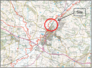
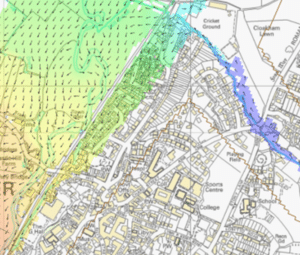
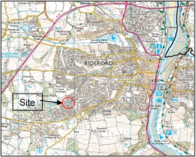
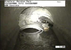
Moreton Park Road, Bideford
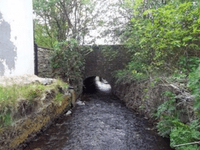
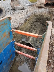
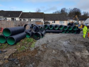
The £300k scheme to repair a section of collapsed culvert at Moreton Park Road, Bideford was completed in August 2018. The culvert runs under several private gardens and the collapse resulted in the creation of a sinkhole which posed a flood risk to the nearby properties. The repair work involved evacuating and replacing 76m of damaged and collapsed culvert.

Location of flood scheme 
Collapsed culvert As the culverted watercourse runs through private land it is the responsibility of the riparian owner to ensure the watercourse is free-flowing and clear of blockages. However, due to the complexity of the works and the culvert crossing under several landownerships, Devon County Council deemed it unrealistic and unsafe to expect the riparian landowners to undertake the work in isolation. Devon County Council therefore coordinated and contributed significantly to the repair of the culvert improvement alongside a private insurance contribution and Flood Risk Grant in Aid. Work was completed in June 2018, with maintenance responsibilities now passed back to the landowners.

Installation of new culvert Repair and replacement of culvert -
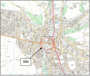
Braunton Case Study

Braunton flood scheme location Braunton is a large village approximately 7km northwest of Barnstaple in North Devon. The village is situated either side of the River Caen which flows from north to south through the village.
Braunton has a history of major flood events with up to 45 properties flooded in December 2004 from overtopping of the River Caen, at least 4 commercial properties flooded internally in July 2011, due to excess surface water and most significantly in December 2012 when 65 domestic and commercial properties suffered internal flooding from a combination of surface water runoff and the River Caen overtopping. As a result there was a significant response and recovery effort including a flood drop-in event in January 2013 and a subsequent flood fair in March for local residents.
Main River Flood Defence Scheme

Braunton December 2012 flooding The Environment Agency completed a £1.2 million flood defence scheme on the River Caen in early 2012 and following the December 2012 flood events carried out additional channel management work to improve the operation of the scheme involving major vegetation and tree clearance, additional bank repairs and further defence improvements.
Highway Flood Investigations
Collaborative working between Devon County Council’s Flood Risk Management and Highway teams has investigated a number of surface water issues that are impacting on the highway drainage systems. Reports have been produced for the Caen Street and St Brannocks Hill areas of Braunton.
Surface Water Management Plan
A full Surface Water Management Plan has been produced for Braunton in partnership and collaboration with the Lead Local Flood Authority, Highways, District Council, Environment Agency, South West Water, Parish Council and local resident representatives. The final report has documented a number of recommendations that will now be reviewed in line with other priorities and funding opportunities. Possibilities for partnership funding contributions will need to be considered between the relevant Risk Management Authorities and key stakeholders to support the funding bid for Flood Defence Grant in Aid which has been submitted and, subject to satisfactory approvals, available for drawing down in 2015/16.
Pathfinder Project
In March 2013 Devon County Council were awarded funding through the Flood Resilience Community Pathfinder Project with Braunton chosen as one of 24 communities in Devon. To date, a number of key achievements have been made:
- Updated Emergency Plan – Tested with the relevant authorities in January 2014 and adopted by the Parish Council in February. Braunton were the first community in Devon to have an Emergency Plan in place.
- A big part of the Emergency Plan was the new early warning system the Rotary Club developed.
- A good working relationship and partnership between all of the relevant emergency and community authorities has successfully been developed.
- A number of retail outlets now display flood and emergency news to the community on electronic noticeboards.
- The local flood group have purchased 4 sand bunkers containing sand, sandbags and plastic sheets.
- A flood warden scheme has started up.
- A greater knowledge and understanding of the Environment Agency’s river levels station data.

Community Emergency Plan desktop exercise in Braunton -
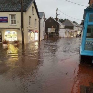
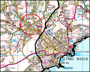
Uplyme

Uplyme flood scheme location Uplyme is a village in East Devon on the Devon-Dorset border. The main river, River Lim runs through Uplyme in an east-west direction with a number of ordinary watercourses feeding into it across the village. The geology of the surrounding area includes flinty superficial deposits which easily wash into the surrounding drainage systems during periods of high runoff.
Uplyme is subject to regular flooding, often with multiple flood events in the same year such as in 2012. Flooding affects both residential and commercial properties and can damage critical infrastructure. 2012 saw flooding on four separate occasions each causing multiple properties to flood internally. Since then flooding has also occurred in 2013 and 2016. Flood risk is driven by the blockage of inadequately sized culverts and is exacerbated by the silting up of downstream systems.
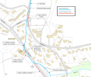
The Uplyme flood improvement works which were undertaken in spring 2018 were funded by Devon County Council, East Devon District Council, Local Levy and Flood Risk Grant in Aid.
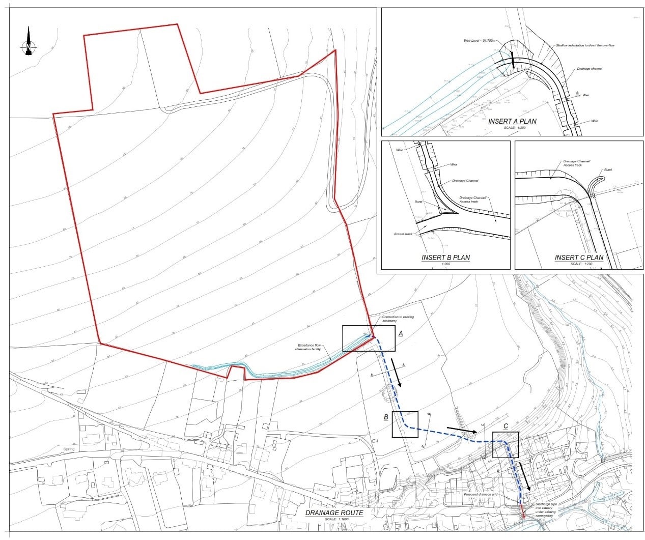
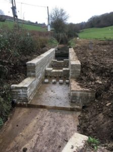
Work that was carried out at Uplyme includes a series of new culverts placed in the village along the watercourse from Cooks Mead to north of the village hall. This will alleviate some of the pressure on existing culvers that have insufficient capacity and carry flood water away from the village centre which suffers the greatest risk of flooding.

Uplyme flood alleviation scheme plan Just north of the village and Pound Lane, there are silt traps that were installed in 2016. The scheme has extended these silt traps and installed watercourse check weirs further up this watercourse to help alleviate pressure and silting up of the newly enlarged culverts further down the village.

New silt traps 
New culvert system The scheme will better protect 10 residential and 2 commercial properties up to the 1 in 100-year flood event. Devon County Council will be responsible for maintenance of the culverts with the parish council managing the silt traps.
-
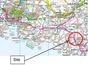
Aveton Gifford – Parsons Brook Case Study

Location of flood scheme Aveton Gifford is a small rural village situated 16 miles South East of Plymouth in the South Hams, at the head of the estuary of the River Avon.
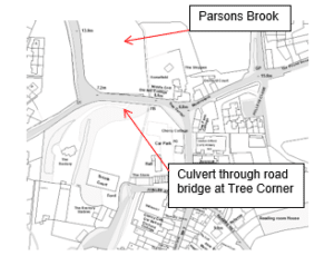
The village is dissected by the Parsons Brook, an ordinary watercourse, which is culverted and bridged at a number of points in the village.
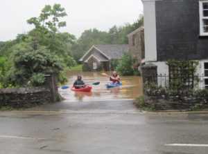
Following the extreme rainfall over much of Devon in 2012, a number of properties in Aveton Gifford were flooded to depths of over 900mm in July and again just days before Christmas after the initial repair works had been completed. Some residents were forced out of their homes for nearly 12 months due to these repeated flood events.
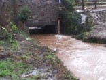
After being made aware of the extreme impact and frequency of flooding Devon County Council’s Flood Risk Management (DCC FRM) team commissioned a study, confirming that the existing culvert arrangement under the old A379 at Tree Corner, was prone to blockage causing a backing up of flows resulting in flooding. An initial design to enlarge the existing culvert, reducing the possibility of blockage, was considered and evaluated to ensure that it would not result in an increased flood risk downstream.
Funding through the Flood Defence Grant in Aid process would have required time and a fully detailed robust scheme with appropriate cost-benefit, however the frequency and depth of flooding identified this as a high priority and urgent action was required. Funding was therefore sourced locally with the large proportion being secured through Local Levy and DCC FRM. Contributions were also provided by the affected and subsequently benefitting residents and the Parish Council to ensure the scheme was delivered promptly.

Residents at Tree Corner 
Parsons Brook Once funding had been secured by the FRM team at the end of September, it was apparent through communications with DCC’s bridges team that there was a high possibility of commencing works in October by engaging our term contractor South West Highways. A month of high intensity work carried out by the FRM’s newly appointed Project Engineer, with assistance from other FRM team members enabled the scheme to be designed and all agreements put in place to allow works to progress at such short notice.

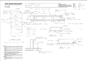
DCC Scheme drawing Works were completed on the 20th December 2013 and the project is a great example of collaborative working between key stake holders and DCC FRM. The extract and photo below is taken from the Aveton Gifford Parish Council website and gives an update from the residents as to the effectiveness of the scheme.
Update since the floods in January 2014.
 There were exceptionally high tides in the river from January 2nd through to January 5th, with onshore gales and low atmospheric pressure. Accompanying heavy rainfall and saturated ground meant that tides remained extremely high until the 7th. Work on enlarging the culvert under the bridge at Tree Corner was completed on 20th December, and in the three weeks following this it was proved to have made a noticeable difference. Frequent heavy rainfall quickly gave rise to similar conditions which caused the three nearby cottages to flood in past years, but the new culvert was able to cope with increased quantities of flood water, and Parson’s Brook continued to flow.
Pathfinder Project
March 2013 Devon County Council were awarded funding through the Flood Resilience Community Pathfinder Project. Aveton Gifford was chosen as one of 24 communities in Devon. The project is design to support local communities to tackle flood resilience issues. As a result, a flood resilience group was set up involving many householders who have been affected, representatives from the Parish Council, the village hall, the schools, and several others. The group in conjunction with Devon County Council, South Hams District Council and the Environment Agency have or are in the process of:
- Identified the vulnerable areas and the causes of flooding in the parish.
- Understand what the threats are in terms of weather conditions.
- Understand what the threats are in terms of safety.
- Set up a local flood alert system.
- Raise awareness with the local communities of the risk of flooding, the danger of flood water and where the Community Emergency centre is via the local newsletter, social media and the Parish Website. Information on where sandbags are and how to use them, advise on keeping culvert, drains and gullies clear etc. and how to report blocked surface water drains with highways.
- Produced and tested a local community Emergency plan which contains a flood action plan.
- Purchased and installed a sand bag store.
-
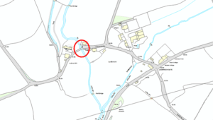
Ludbrook – Community Flood Scheme Case Study
 Ludbrook is a small rural hamlet situated 2 miles south east of Ivybridge in the South Hams, at the head of the estuary of the River Erme. The hamlet is dissected by the Ludbrook, an ordinary watercourse, which is bridged at a central point in village.
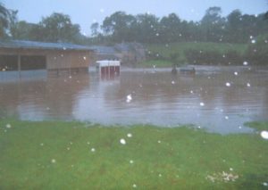
Over the weekend of 7th and 8th July 2012, the South Hams and East Devon regions experienced intense rainfall resulting in the flooding of over 230 residential and commercial properties across Devon. Within the South Hams the rainfall was characterised by high intensities over a short duration with maximums of up to 97mm falling within the Avon catchment.


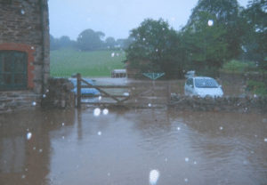
Following this extreme, intense rainfall, surface water flooded the Highway from Ludbrook Gate towards Elm Barn and the walled highways in effect, became river channels. The bridge at the centre of Ludbrook acted as a pinch point and caused the water from the Ludbrook to backup and flood both land and property. The flood water also resulted in a substantial amount of highway damage in the area.
To prevent further damage to property, the residents at Ludbrook embarked on a community scheme to prevent further flooding. The scheme they designed included the installation of a triple flood relief culvert structure across the road to convey floodwater from the upstream of the road to an open lower field downstream. This would allow the open rural field to act as additional storage during flood events where water will then be stored in the field until levels drop in the stream and allow the floodwater to be passed back into the stream.
The works were estimated to be over £36,000 plus the highway reinstatement costs. The residents approached Devon County Flood Risk Management (FRM) team regarding funding and in partnership with the residents, it was agreed that the FRM team would make a £10,000 contribution towards the community scheme, DCC Highways would carry out reinstatement of the highway and DCC bridges providing engineering advice to the designer and contractor. The balance of funding was provided by the affected residents.

Once funding had been secured by the residents at the end of November 2012, construction started and works were completed by January 2013. The works successfully prevented repeated flooding following subsequent high intensity rainfall events in 2013 following its construction. The project is a great example of collaborative working between the community at Ludbrook and the various teams within Devon County Council.

 The Street area of Branscombe is a small rural community situated 15 miles east of Exeter in East Devon. The natural topography for the area is such that the catchment has a long and narrow appearance which runs in a northwest / southeast direction and is approximately 1.8km2. The catchment elevation ranges from 170m AOD at its northern most point to less than 75m AOD in the village to the south. The site is flanked on both sides by steep slopes which converge on to the Street area of Branscombe
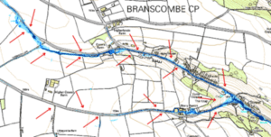


 There were exceptionally high tides in the river from January 2nd through to January 5th, with onshore gales and low atmospheric pressure. Accompanying heavy rainfall and saturated ground meant that tides remained extremely high until the 7th. Work on enlarging the culvert under the bridge at Tree Corner was completed on 20th December, and in the three weeks following this it was proved to have made a noticeable difference. Frequent heavy rainfall quickly gave rise to similar conditions which caused the three nearby cottages to flood in past years, but the new culvert was able to cope with increased quantities of flood water, and Parson’s Brook continued to flow.
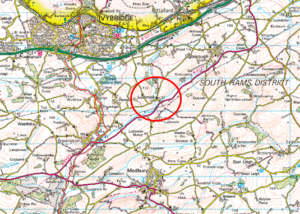 Ludbrook is a small rural hamlet situated 2 miles south east of Ivybridge in the South Hams, at the head of the estuary of the River Erme. The hamlet is dissected by the Ludbrook, an ordinary watercourse, which is bridged at a central point in village.
Last updated: September 2020