Information on Devon’s environment has been mapped on our Environment Viewer. These maps give access to spatial (geographic) data for Devon on a wide range of topics. These include:
- Ecology and geology maps
- Nature Recovery Network maps*
- Flood risk maps
- Historic environment maps
- Landscapes maps
- Planning maps
- Public access maps
- Woodland planting considerations map**
*Phase 1 Nature Recovery Network Maps. Please note that this Nature Recovery Network mapping is in development. Before you use these layers please read the Guidance at Devon Nature Recovery Network Map – Devon Local Nature Partnership (devonlnp.org.uk) and send any comments and suggestions through to nature@devon.gov.uk. For information on Biodiversity Net Gain in Devon and Strategic Ecological Significance scoring please see the Devon BNG Guidance at Devon-BNG-Guidance-at-July-2022.pdf
**NOTE this Woodland planting considerations map shows data pre-selected from all environmental topics above that are relevant to woodland creation. To understand more, including why the data is relevant, and what to do if data is shown on or very near your potential planting site, see this table of environmental considerations from the Right Place Right Tree guidance.
Tips for using the Viewer
1. ![]()
Note there is an About or Information button at top left to provide help. This should automatically open at startup. Click on one of the map weblinks above, read and scroll to the bottom of the terms and conditions and tick to say you agree to use the Viewer.
2. ![]()
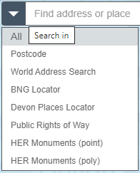
Search function. Type in ‘Find address or place’ to locate an address, school or place. Use lefthand dropdown arrowhead to use various search options, such as postcode, BNG locator (British National Grid), etc. Then press return or magnifying glass and the map will then zoom to your area of interest. On a PC/laptopn you can use the mouse to drag map to area of interest.
3. ![]()
Zoom control. You can zoom using the ‘+’ and ‘-‘ buttons. If on a PC/laptop you can use scroll using the mouse wheel to zoom. You can also lasso an area by ‘Shift left mouse click and drag cursor’ to zoom into an area. Zoom into an area of interest to reduce the amount of data the map has to load. Loading time will increase if you a) zoom out to view a large area, such as district or County level and b) select/tick on many layers.
To pan around the map, click/touch the map and move, release to stop.
4. ![]()
Reset to the full map extent, home. Do not tick too many layers when zoomed out to a large scale, eg viewing at County or District level, as it will take a longer time for the data to load.
5. ![]()
Use the GPS location to position the map at your current location. Click ![]() to de-select GPS.
to de-select GPS.
6. ![]()
Measure tool, allows measurement of distance and area. Select measure tool then click on map for start point and click once for subsequent points, and double click for end point. Click Clear to stop using this tool or click icon again to de-select.
7. ![]()
Print the visible map.
8. ![]()
Add data function, to add any external data or data of your own.
9. ![]()
Select. Use this tool to select a feature, such as a point, polyline or polygon, of the data you have opened in the layer list. In the Select window, tick the layer of interest and then on the map ‘Press down to start and let go to finish’ to drag over a feature of interest to select.
10. ![]()
Share map. Creates:
a) a weblink to this app (includes options such as select current map extent, add a marker on the map and remember layers visibility) and
b) a weblink for embedding this app in a website.
11. ![]()
Legend (top right), displays selected layers, explains the colours and symbols visible on the map.
12. ![]()
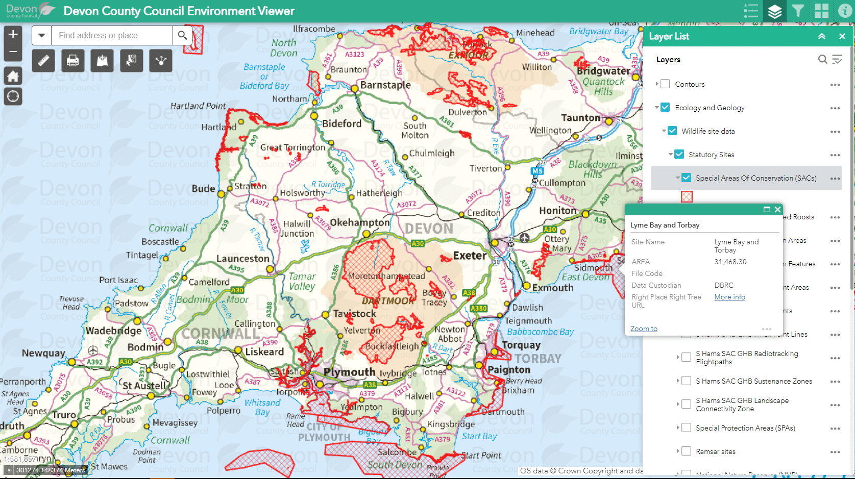
To view data held by Devon County Council, click Layer List icon. A Layer List box should pop up showing the top tier groups of datasets. You’ll see these are grouped under environmental topic headings e.g. ecology, historic environment etc. You can expand the list by clicking on the arrow to the left of the ticked box.
- Layers list (top right), allows map layers to be switched on and off.
- Many layers can be selected to view at one time. Layers higher up the list will appear over the top of layers lower down the list. You may have to uncheck higher layers to see lower layers hidden underneath on the map. The layer position in the layer list is random and does not infer a level of importance or value.
- The 3 dots to the right side of the layer provide extra functions, allowing you to zoom to the complete layer and change the transparency.
![]()
- Where a layer has several tiers of layers, all the upper-tier groups need to be ticked on to view the lower tier layers.
- If a layer title appears as faded grey text in the Layer List, zoom in on the map as some layers only appear on the map when zoomed in to specific scales.
- Note that a large dataset will take time to load, and if you open several large (data-rich) datasets (tick several layers) that will also slow the Viewer, especially if you have low broadband speed. If you zoom in to a specific location (such as farm or parish level) and open the layers there, it will be quicker to load onto the map view than trying to open and view the same data at a larger scale (such as county or district level).
13. ![]()
Filters the data displayed on the map, standard filters are available for Historic Environment.
14. ![]()
Base map gallery (top right), allows basemap layers to be switched on and off. Aerial maps and historic maps are found here. The Master Raster (Greyscale) is useful to reduce colour confusion when lots of data layers are open.
15. ![]()
Coordinates bar. To find out the grid reference of a point on the map, click on the cross-hair point at bottom left of grid reference, then click on map to find your coordinates of preferred place (drops green marker). Click cross-hair again when you no longer need this tool. You can copy and paste this grid reference.
![]()
Conditions of use and data ownership
All of this data is made available by Devon County Council. The data is either owned and managed by Devon County Council, or derived from data given by other organisations (such as the Environment Agency, Natural England and Devon Biodiversity Records Centre, amongst others) who allow Devon County Council to display their data on this website.
Please note that the Environment Viewer has been live since spring/summer 2016 and is being improved all the time. We are aware that it is currently quite slow to load and we are in the process of resolving this issue.
Feedback and comments regarding the data should be sent to:
- Ecology, geology and woodland creation – nature@devon.gov.uk
- Flood risk – floodrisk@devon.gov.uk
- Historic environment – archaeol@devon.gov.uk
- Landscapes – landscape@devon.gov.uk
- Planning – planning@devon.gov.uk
- Public access – prow@devon.gov.uk