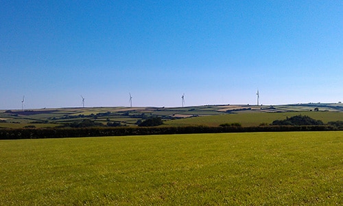
This is a simple, agricultural landscape dominated by the sky within an open, westerly aspect. The smooth hills have rounded profiles, and are covered by a patchwork of large, regular fields. Views are long and wide, sometimes with glimpses of the sea or estuary as a backdrop. The steep valleys which punctuate the downland run like wooded ribbons across the landscape, contrasting with the farmland in their rich colours and textures. These valleys have a secluded and secretive character. They are very tranquil, the only sounds often being birds and running water; and their sunken lanes have a timeless quality.
-
Context
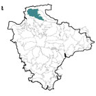
 This area is located to the north of Barnstaple and comprises high open farmland interspersed with secluded wooded valleys. To the north is the North Devon High Coast with its coastal combes; to the east a gradual transition to the wooded, intricate landscapes of the Exmoor Fringe; to the south a gradual transition to the Codden Hill and Wooded Estates and also a more abrupt transition (marked by the change in topography) with the Taw-Torridge Estuary. To the west is a gradual transition (with increasing coastal influence) to the North Devon Coastal Downs.
-
Constituent Landscape Character Types
Constituent LCTs: 3H: Secluded Valleys, 5C: Downland Part of NCA: 145: Exmoor
-
Distinctive Characteristics
- Northern and coastal parts underlain by banks of resistant Morte slate; southern parts underlain by softer banks of sandstone, shales and mudstone, resulting in more undulating topography.
- Rolling downland with broad rounded ridges and hilltops, declining in the south to meet the Taw-Torridge estuary and Barnstaple.
- Springs and small streams in steep-sided V-shaped valleys and combes carving through the downland.
- Valley sides often densely wooded with sessile oak woods, beach-dominated broadleaved woodland, wet woodland on valley floors, and some conifer plantations.
- Sparse woodland cover on upland areas, limited to occasional blocks of coniferous plantation (e.g. King’s Warren), small farm woods and wind-sculpted pine shelterbelts; sporadic clumps and avenues of beech on prominent ridgelines – e.g. above Shirwell Cross.
- Strongly agricultural landscape, with a rural character, pastoral fields in valleys, and a mixture of pastoral and arable use on the better-quality soils on higher land.
- Mixture of medium-sized curving medieval fields (particularly in valleys) and larger post-medieval and modern fields with straight boundaries; some remaining areas of open downland.
- Field boundaries that include grassy Devon banks with wind-pruned gorse and scrub (in areas of coastal exposure), flower-rich banks with mixed-species hedges, Morte slate-faced banks, and square-cut beech hedgebanks particularly close to Exmoor.
- Post-and-wire fences enclosing some of the more intensively farmed fields.
- Extensive areas of valley-side ancient woodland, plus fragmented species-rich acidic and neutral grassland, rush pasture, scrub and bracken.
- Clusters of prehistoric features including round and bowl barrows associated with ridge roads egg A3123, and ancient hilltop enclosures.
- Parkland estates in the southern parts of the area lending a softer, designed character and providing rich wildlife habitats notable for their lichens, wood decay invertebrates and rare bats.
- Stone bridges, mills, weirs, and disused quarries reflecting the valleys’ industrial heritage.
- Dispersed farmsteads sited in dips in the landform and small nucleated villages and hamlets located in tributary valleys and around crossroads; much of the area remains undeveloped.
- Strong vernacular including cream and whitewashed cob/ render; exposed local stone with slate roofs and some thatch, e.g. Heanton Punchardon and Prixton; characteristic square stone church towers.
- Straight roads enclosed by hedgebanks across upland areas, with occasional gaps providing long views across the landscape; steep, twisting valley roads between fern-rich banks.
- Caravan and holiday parks, as well as other tourism-related land uses, especially close to coast
- Expansive views from hill summits to the coast and estuary; contrasting secluded and intimate character within valleys.
Evaluation
-
Special Qualities and Features:
- High scenic quality, with northern parts of the area contributing to the settings of the North Devon Coast AONB and Exmoor National Park.
- Smooth rolling skylines (often only broken by square church towers) that form the backdrop and setting to surrounding settlements and protected landscapes.
- Locally high levels of tranquillity away from settlements and major roads.
- Bradiford Valley SSSI with ancient oak woodland, mill pond, leat, stream and meadow habitats.
- Extensive areas of ancient semi-natural woodland on valley sides and numerous CWSs.
- Several RIGSs covering geological exposures.
- Very large number of SMs – including pre-historic barrows, camps, hillforts and earthworks – often in prominent elevated positions in the landscape.
- 18th century parkland at Youlston Park (Grade II) and Castle Hill Estate (Grade I) on the Register of Historic Parks and Gardens and of national significance for the numbers of veteran and ancient trees it supports; area also includes part of the National Trust-owned Arlington Court estate.
- Several Conservation Areas, including Ashford, Heaton Punchardon, Marwood and West Down.
- Good network of lanes, tracks and public rights of way providing recreational access.
Forces for Change and Their Landscape Implications:
-
Past and Current
- Recreation pressures, including visually-intrusive caravan parks and tourist development on coastal peripheries (e.g. East Stowfold Barton).
- Increased farm, industrial and recreational traffic on rural roads, reducing tranquillity and damaging hedgebanks.
- Decline in woodland management reducing age- and species-diversity; localised replanting of ancient oak woodland with conifers.
- Intensification of agriculture, resulting in increase of land in arable cultivation, loss of hedgerows and other wildlife habitats, and scrubbing-up of under-grazed marginal land such as steep valley sides.
- Construction of visually-prominent large scale buildings (barns, industrial estates, etc.) changing the open and undeveloped character of the landscape.
- Introduction of vertical skyline features such as telecommunications masts on summits.
- Views to modern development across the Taw-Torridge Estuary (e.g. Barnstaple, Braunton, Northam, Westward Ho!)
- Past quarrying activities, locally-intrusive in the landscape.
- Light spill from surrounding settlements reducing the visibility of stars.
- Demand for offshore and onshore wind turbines, including the consented scheme for 22 x 110m turbines at Fullabrook Down which will be highly visible within the landscape.
-
Future
- Further growth in popularity of the area for recreation and tourism, and as a place to live, leading to further demand for facilities (including farm conversions and more camping/ caravan sites), infrastructure and increased traffic levels.
- Climate change affecting seasonal weather patterns and allowing new pests and diseases to thrive, potentially changing the species composition of woodlands and other semi-natural habitats.
- Increased storm damage, with loss of distinctive hedgerow beech trees and hill-top beech clumps.
- Use of agricultural land for new crops (including bio-energy crops) altering landscape character.
- Further renewable energy schemes, including offshore and onshore wind turbines, solar arrays on south-facing slopes, small-scale hydro-power and domestic-scale renewables which may affect the built character of the area.
- Cumulative impacts associated with any further onshore wind farm development.
Strategy
-
Overall Strategy:
To protect the area’s scenic quality, flowing skylines, agricultural landscape and tranquil valleys, enhancing its role as a setting for and backdrop to adjacent AONB and National Park landscapes. The open views and smooth skylines of the downs are retained, and visually intrusive development is avoided. Valleys maintain their tranquil, secluded character. Sustainable agriculture is supported, and landscape features such as hedgerows and woodland are well-managed. The biodiversity of the agricultural landscape and parklands is enhanced. The numerous archaeological sites are protected and well-managed.
Guidelines:
-
Protect
- Protect the landscape’s far-reaching views (including those to the coast and Exmoor National Park) and flowing open skylines, avoiding insensitively-sited development; ensure local church towers remain landmark features on skylines.
- Protect the landscape’s rural character and high levels of tranquillity through the control and management of development, including highways.
- Protect the sparse settlement pattern of farmsteads and nucleated villages and hamlets nestled in valleys and landform dips; ensure that any new development respects local vernacular building styles and settlement forms, whilst incorporating sustainable design.
- Protect and repair characteristic features, e.g. stone bridges.
- Protect rural lanes, resisting intrusive signage and unsympathetic highways works.
- Protect and appropriately manage the landscape’s archaeological heritage including prehistoric burial sites and ancient hilltop enclosures, providing sensitive interpretation where appropriate.
- Protect and manage the landscape’s historic parkland estates, ensuring that the location of any new development does not affect their setting or designed views; parkland trees should be protected from damage to their root systems through ploughing or agricultural inputs; old trees should be retained as wildlife habitats and new generations of open grown trees should be encouraged.
-
Manage
- Manage (using traditional techniques such as coppicing) the landscape’s valley-side ancient woodlands to maximise age diversity and to achieve a species diversity appropriate to the local conditions.
- Manage the beech clumps and pine shelterbelts which form characteristic features within the open landscape.
- Manage and replant as necessary the network of beech-dominated hedgebanks and characteristic wind-sculpted hedgerow trees to reinforce field patterns; ensure new hedgebank construction reflects local traditions in terms of species, bank height and width, and patterns of stone-facing.
- Manage and enhance the wildlife interest of agricultural fields by encouraging creation of uncultivated field margins, grass buffer strips around intensively farmed fields and other wildlife-friendly farming methods that also help reduce diffuse pollution into water courses draining the downland.
- Manage and re-link fragmented patches of species-rich grassland and rush pasture, supporting farmers to extensively graze these areas as integral parts of their farming systems.
-
Plan
- Plan for the increasing tourism demands and expansion of coastal settlements through the development of green infrastructure links to the landscape, creating opportunities for sustainable access and recreation inland, and taking pressure off the coast.
- Plan for population increase and development pressure within the small settlements, with new sustainable development appropriately linked to facilities and infrastructure.
- Plan to reduce light pollution from surrounding settlements.
- Plan to explore the potential for small-scale hydro-electric power from the area’s streams.