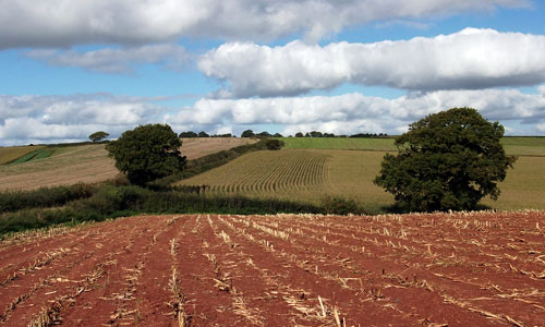
A settled and farmed lowland landscape, which gives the impression of being a fertile and prosperous agricultural area. The patchwork of fields and hedgerows is characterised by red soils, a wide variety of crops and numerous orchards, giving the area a rich variety of colours and textures, particularly in spring and late summer. The tree-fringed rivers Yeo, Creedy, Culm and Exe snake in meandering courses across their wide floodplains, past historic mills, bridges and weirs, all of which contribute to the time-depth of the landscape. The numerous prehistoric barrows hint at earlier phases of the landscape’s evolution.Crediton, with its historic town centre and splendid red stone parish church gives its surroundings a more developed character.
-
Context
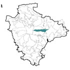
 This relatively flat area contains land to the east and west of Crediton, and is dominated by several river valleys. It includes parts of the valleys of the Yeo (and its tributary the Creedy) in the west and the Culm in the east as well as the productive farmland between them centred on the Exe. To the north are transitions into the steeper landforms of the Exe Valley, Cullompton Rolling Farmland and the Crediton Rolling Farmland. To the west is a gradual transition into the more elevated landscapes of the High Taw Farmland. To the east (beyond the Culm valley) are the Clyst Lowland Farmlands and to the south are the more wooded landscapes of the Yeo Uplands and Slopes and the Exeter Slopes and Hills.
 -
Constitutent Landscape Character Types
Constituent LCTs: 3B: Lower Rolling Farmed and Settled Valley Slopes, 3C: Sparsely Settled Farmed Valley Floors, 3E: Lowland Plains Part of NCA: 148: Devon Redlands -
Distinctive Characteristics
- Underlying geology of Permian red sandstone (with occasional igneous intrusions), with a gently undulating landform containing several wide river valleys.
- The Rivers Yeo, Creedy, Culm and Exe meandering through wide, active floodplains, fed by numerous smaller streams (often originating at springs).
- Occasional scattered woodlands and copses, plus numerous hedgerow and riparian trees giving the landscape a well-treed appearance.
- Good quality agricultural soils (grade 1 or 2); rotational arable farming with some improved pasture.
- Large numbers of surviving and former traditional orchards (particularly around Colebrook and Shobrooke), adding seasonal colour and texture to the landscape and providing a habitat for wildlife.
- Fields that are generally medium-large and semi-regular in shape, with extensive areas of surviving medieval enclosures based on strip fields, and ‘Barton’ fields (15th to 17th century), notably around villages and to the west of Crediton.
- Fields divided by thick – often flower-rich – hedgerows, sometimes containing hedgerow trees; varying patterns of hedgerow management – some are grown-out whilst others are closely flailed.
- Semi-natural habitats that include woodlands, copses and valley-floor wetlands.
- Parkland estates (e.g. Shobrooke Park and Creedy Park), often in valley-side locations to maximise views out, that locally influence the character of the landscape.
- Numerous archaeological sites, including prehistoric barrows and a Romano-British villa.
- Many surviving historic features within the landscape, including Yendacott Manor, wayside crosses, medieval square-towered churches and stone bridges.
- Historic market and wool town of Crediton the largest settlement, established in Saxon times and serving as the meeting-point of trade routes from Okehampton, Exeter, Tiverton and Barnstaple; other parts of the area are relatively sparsely-settled, with scattered farms (often large) and occasional nucleated villages e.g. Thorverton, Shobrooke, Brampford Speke and Stoke Canon.
- Buildings exhibiting a variety of styles, but with cob, thatch and local red sandstone commonly-used as building materials.
- Villages and farms connected by a network of lanes, often straight and running between high hedgebanks; more major roads (e.g. A461, A377) and railway lines following valley floors.
- A quiet and peaceful landscape, often visually self-contained, but with occasional long views along river valleys.
-
Special Qualities and Features:
- Undeveloped high land north, west and south of Crediton that provides a valuable setting to the town.
- Extensive SSSI in the Exe valley at Brampford Speke, illustrating the active processes which form contemporary floodplains along Britain’s rivers.
- Several CWSs, including wet and valley-side woodland, and wetland sites; RIGS at Lakes Bridge, near Brampford Speke, containing a type exposure of Brampford Speke sandstone.
- Ancient semi-natural woodland at Yendacott Copse.
- Varied geology demonstrated in the number of RIGSs, with examples of various sandstone and Breccia beds, and exposures of volcanic lava.
- Part of National Trust Killerton Estate on eastern edge of the area; Shobrooke Park (Grade II on the Register of Historic Parks and Gardens) with early 16th century deer park, formal gardens and 19th century parkland, and Creedy Park.
- Conservation Areas covering the historic cores of Crediton, Knowle, Coleford, Colebrook, Yeoford, Thorverton and Brampford Speke, plus numerous historic buildings (farmhouses, agricultural buildings, bridges, mills etc) throughout the area.
- Concentration of prehistoric SMs (barrows, a cursus and enclosures) in the central part of the area.
- Other SMs including a Romano-British villa at Downs (east of Crediton at the confluence of the Creedy and Yeo Rivers), medieval stone-arched bridges over the Culm at Paddleford and Stoke Canon and St Martin’s chapel at Broadnymett.
- Strong ecclesiastical history, with the first cathedral in Devon built in Crediton in 909 AD (no longer surviving); magnificent Norman and medieval parish church of vivid red sandstone with a pinnacled tower, of almost cathedral-like dimensions.
- Associations with the missionary St Boniface, born in Crediton in around 680 AD.
- The Two Moors Way recreational route (linking Dartmoor and Exmoor) running north-south through the western part of the area, plus long-distance recreational routes following the Exe valley (Exe Valley Way) and River Creedy (Devonshire Hartland Way).
-
Past and Current
- Past farm intensification resulting in (for example) amalgamation of fields, loss of hedgerows, orchards and biodiversity, and introduction of large-scale agricultural buildings which may be visually intrusive
- More recent trends including the use of non-natural materials such as plastic and fleece to protect crops that may also be intrusive within the landscape.
- Increased traffic (including wide farm machinery) damaging hedgebanks and verges, resulting in a decline in plant species alongside roads.
- Threat of new pests and diseases affecting trees (e.g. Phytophthora pathogens), potentially resulting in the loss of trees and woodlands from the landscape.
- Invasive water-borne weeds such as knotweed and Himalayan balsam affecting native riparian vegetation.
- Loss of tranquillity and dark night skies due to the area’s proximity to Exeter and main roads.
- Peripheral development of towns and villages such as Crediton and Stoke Canon with associated infrastructure e.g. water works in valleys introducing new built structures to the landscape; expansion of Crediton up the valley sides causing the town to become more visually prominent in the landscape.
-
Future
- Uncertainty over future levels of agricultural funding and grants, potentially resulting in changes in livestock numbers and crop types, and reduced upkeep of historic features such as hedgerows and historic agricultural buildings.
- Demand for renewable energy schemes, including solar arrays and biomass crops, potentially introducing large-scale structures into the landscape; domestic and community scale schemes may also have a cumulative effect on landscape character.Increased flood risk in low-lying areas such as this due to higher precipitation caused by climate change.
- Climate change affecting seasonal weather patterns (e.g. summer drought, winter flooding) potentially causing loss of drought- and wet-intolerant species and changes to crop selection and farming practices.
- Continued development pressure from settlements such as Crediton, resulting in expansion of settlements onto valley floors and higher land.
-
Overall Strategy:
To protect the area’s rural character and enhance the landscape and biodiversity interest of the agricultural landscape. The area’s distinctive patchwork of hedged fields, traditional orchards and varied agriculture is retained and enhanced. The river valleys are well managed to function as flood plains and as a biodiversity resource. Archaeological and historic features within the landscape are protected, and opportunities for access are enhanced.
-
Protect
- Protect hedgerows and hedgerow trees from further loss, in order to retain the ‘patchwork’ effect of fields within the landscape.
- Protect and manage surviving orchards.
- Protect the setting of Crediton.
- Protect buried and visible archaeological sites, avoiding damage by ploughing or vegetation growth.
- Protect and sensitively restore where necessary historic features such as bridges and mills.
- Protect the historic built fabric of the area, ensuring that any new development is appropriate in scale, well designed and sited, and respects traditional vernacular styles and materials.
- Protect historic lanes and their associated hedgebanks, resisting unsympathetic signage or highways measures.
- Protect floodplains from development, enabling them to retain their functions as floodplains, and reduce the likelihood of downstream flooding.
- Protect high-quality agricultural land from development.
-
Manage
- Manage agricultural land, retaining historic features and enhancing its biodiversity through (for example) the introduction of grass buffer strips around the edges of arable fields, and re-linking hedgerows as wildlife corridors; promote the learning of traditional agricultural skills.
- Manage trees, hedgerows, hedgebanks copses and woodland to promote species diversity (using traditional techniques such as pollarding and coppicing where appropriate).
- Manage river corridors and floodplains to enhance their biodiversity and flood water storage function.
- Manage and ideally control or eradicate invasive water-borne weeds.
- Manage parkland and veteran trees, including planting the next generation of specimen parkland trees and encouraging open-grown trees within the wider countryside.
-
Plan
- Plan to extend and link semi-natural habitats and hedgerows to increase their biodiversity value and resilience to climate change.
- Plan to improve the rights of way network along river valleys and into areas of higher land, to increase the accessibility of the countryside.
- Plan appropriate screening of agricultural buildings where visually-intrusive.
- Plan sensitive siting and design of any proposed settlement extensions to settlements, in order to minimise impacts on the landscape, and aim to reduce developmental pressure on floodplains.
- Plan any future development of Crediton to ensure it is sensitively-sited, and incorporates green infrastructure to link the town with the surrounding countryside.
- Plan to reduce light pollution from Crediton and main roads.
- Plan to investigate the opportunities for small-scale hydropower on suitable rivers and streams.